
Бесплатный фрагмент - Meru Mountains
Hyperborea and Aryan ancestral homeland

Collection of scientific papers S.V. Zharnikova’s “Meru Mountains” (Hyperborea and Aryan ancestral homeland) is devoted to the problem of identifying the main centers of the Aryan ancestral homeland — the Meru Mountains (Hara and Kukarya mountains, Riphean and Hyperborean mountains). The works presented in it give an answer to the question of their location. These articles outline the circle of lands of the ancestral home of the Indo-Europeans — Hyperboreans; find ancient Aryan cities, rivers, sacred reservoirs.
Russia is a country of eternal changes and completely non-conservative, their country is beyond conservative customs, where historical times live, and do not part with rituals and ideas. The Russians are not a young people, but the old ones — like the Chinese. They are very old, ancient, conservatively preserved all the oldest and do not refuse it. In their language, their superstition, their disposition, etc., one can study the most ancient times. (Victor von Hen. 1870)
Arctic India
Dear readers do not be confused by such a strange phrase — Arctic India. We are not the first to pronounce it. 94 years ago, in 1903, a book was published in Bombay under the even more intriguing title “The Arctic Home in the Vedas”. Its author, an outstanding scientist and public figure B. G. Tilak, who for many years studied the Vedas, Mahabharata, Puranas and Avesta, came to the conclusion that the most ancient ancestral home of the Aryans was somewhere near the Arctic Circle.
And he certainly had reasons for such a statement. It is worth recalling, for example, many hymns of the Rig Veda, where the period of “shimmering twilight”, called the dawn, is mentioned, where it is said about a long, many-day night, that the constellation Seven Rishis (Ursa Major) is always visible high in the sky. Or the words of the “Laws of Manu” that “the Sun separates day and night — human and divine… The gods have day and night (human) year, again divided in two: day — the period of movement of the Sun to the north, night — the period of movement to sub.” But this is a polar day and a polar night! There are other examples of observations of the ancestors of the Aryans for the specific natural phenomena of the Arctic.
So in the “Tale of Galava” by Mahabharata Garuda, telling about the northern ascended country washed by the waters of the Milky Sea, he talks about the constellations that make a complete revolution around the motionless Dhruva (the Polar Star) during one night. The belt of these constellations beyond the horizon is definitely indicated: these are the Seven Rishis (Ursa Major), Arunhati (Cassiopeia constellation), and Swati (Medusa star from the polar constellation Perseus). But all these constellations do not go beyond the horizon and describe a circle that can be traced during one winter night (since there is simply no night here in summer) only in areas not further than 56° N. It is well known that the farther north the geographic position of the observer, the greater the radius of non-stopping stars.
It is in the north, according to Mahabharata, that is the zenith of Vishnupada. But the North Star is at its zenith at the North Pole or in the Subpolar countries.
Interestingly, even in the 11th century Abureyhan Biruni noted that in India they “reverently revere the Big Dipper and the North Pole” and believe that “the Pole is Vishnu, to whom the inhabitants of paradise obey; he also is the time that creates and grows, destroys and destroys.” He was genuinely surprised that the Indians knew stars located north of the Arctic Circle, but did not have an idea about the South Pole. Here, probably, it is necessary to recall the descriptions of the Northern Lights — “Apsars living in the North” and sparkling over the Milk (that is, the White Sea).
You must admit that such vast and most importantly very accurate information, transmitted in sacred texts from generation to generation for many millennia, could be obtained and retained only by people who knew the northern lands well and to whom this knowledge was very dear.
We can only regret that the book of B. G. Tilak was never translated into Russian. Perhaps that is why most Soviet scientists were very skeptical of the theory of the polar ancestral home of the Aryans. They believed that the ancestors of the Aryans, who lived in ancient times along the Black Sea, never visited the more northern regions. And information about the Sub-Polar Region was received from the semi-wild tribes, who probably lived in the North of Europe.
Among those who accepted the ideas of B.G. Tilak was the Russian scientist E. Jelachich, who published in 1910 the book “The Far North as the Homeland of Humanity”. Moreover, perhaps, a remarkable Russian researcher, academician A.
I. Sobolevsky, who believed that the ancient Indo-Iranian language lies at the heart of the geographical names of the Russian North.
And only very recently interest in the polar theory of B. G. Tilak has increased dramatically. More and more scientists of our country share his ideas and find him more and more new confirmations. The author for a long time collected, studied and analyzed the geographical names of the European north of Russia. And today we would like to share some results of this work.
Let’s start with such a seemingly strange circumstance that back in 1605, at the court of the Russian tsars, the lands of Russia on the White Sea coast were called India. It is worth noting that in the 17th century, Russian people knew very well where the Hindustan Peninsula is located, with which there was lively trade, and all the more well knew the coast of the Arctic Ocean. And if at the same time they talked about India in the Subpolar region, then they had good reason for this.
After all, back in the early 16th century, travelers wrote that the population living on the banks of the Dvina River “has their own language, although they speak more Russian”, that “the Pechora River has a city and the Papin fortress… its inhabitants speak different from Russian language, called papini. “By 1691, there was a message about the North Russian city, called the Indiager neighbors, that is, the “Indian city”.
And, finally, at the beginning of the 20th century, in the church books of the city of Kholmogory, located near the confluence of the Northern Dvina in the White Sea, the legend that the first settlers in these parts were Chur and Nal, who lived here in ancient times, was preserved. It was with the times of Kura that folk rumor was connected by flint tools and arrows washed from the banks of the river.
It is believed that in honor of Kura and Nalya two islands are named, on which the ancient Kholmogory were located — Kur Island and Nal Island. According to legend, the descendants of the Kura grew over time into a powerful independent people who owned the whole North, the people whom the neighbors called the White-Eye Miracle for their surprisingly bright eyes. Until the beginning of the 20th century, legends about heroic strength, powerful growth, the ability to fly through the air and talk with each other at a great distance from the descendants of the Kura remained in the people. They also associated the appearance north of Kholmogor of the Pur-Navolok fortress, from which the city of Arkhangelsk subsequently grew.
In Mahabharata, Vishnupada is named after a stream that originates in the Kailash plateau. Scientists were somewhat puzzled by the fact that Kailas is in the south in Hindustan, the epos directly points to the north. Perhaps this contradiction can be explained by the following: at Kholmogor the Pinega River flows into the Dvina. It flows in the red-brown shores, takes its source from a flat hill. And this source is called the Kailash River.
By the way, there are a lot of such interesting geographical names in the European North of Russia. Here are some of them. The highest peak of the Subpolar Urals is called Narada. Next to it stands Mount Manaraga and the river Manaraga flows. Here, in the North, near the Lake Onego, rivers flow — the Ganges, Ganesha, Sivaruchey, Padma, Lakshma and others.
Does not the memory of the rivers of the Mahabharata evoke the names of the rivers and lakes of the Russian North — Alaka, Anga, Jalya, Ida, Ila, Kai, Manasa, Pavana, Palava, Suda, Sura, Sharya, Shona, Khaimovatitsa. And hundreds and thousands of names of rivers, lakes, mountains and villages of the North, which are simply impossible to explain with the help of languages other than Vedic Sanskrit. These are Indega, Idoga, Indomanka, Baidara, Varaka, Varida, Vazha, Varza, Virama, Deviaka, Ira, Karaka, Karna, Kaura, Kapya, Kundola, Kusha, Lala, Mandara, Mera, Maura, Sara, Sagara, Sindosh, Siti, Sarga, Swar, Swaga, Sumerka, Sukhana, Taka, Tara, Tarna, Udora, Una, Ura, Ustra, Harina, Haruta, Kharya, Shambovka, Shidra, Shura and many others.
The descendants of Kura and Nalya, residents of the Russian North, carried through the millennia to the present day the ancient names of their rivers and lands, and this testifies to what their ancestors, the first settlers, spoke in Sanskrit, which was freed from the glacier, the White Sea coast. Is it so? — You ask. Think so. For you, this is information for consideration. You can agree, but maybe offer your ideas and finds.
The author wanted to tell you about the Russian North, its secrets, which are gradually beginning to be revealed. And also about the peoples that turned out to be hidden by a dense veil of time.
On the possible location of the Holy Hara and Meru mountains in Indo-Iranian (Aryan) mythology
The location of the legendary Hara and Meru, the holy northern mountains of the Indo-Iranian (Aryan) epos and myths is one of the many riddles in Eurasian ancient history that has been troubling researchers for over a century and prompting ever more, sometimes totally contradictory, hypotheses. As a rule, they are believed to be the Scythian Ripei or Hyperborei mountains mentioned by the authors of antiquity. Over 80 years ago The Arctic Home in the Vedas,1 by the outstanding Indian political figure, Bal Gangadhar Tilak, launched a series of publications related to this subject in one way or another and continued to this day. The answer has never been found, as obvious from the two most recent publications — a book by G. Bongard-Levin and E.Grantovsky From Scythia to India (1983),2 The Ethnogeography of Scythia by I. Kuklina (1985).3 The two so-called Ripei Mountains locations, which the books propose, are mutually exclusive, though the authors proceed from the same ancient myths, historical sources and data.
Bongard-Levin and Grantovsky, analyzed the Avesta, Rigveda, Mahabharata, the works of Herodotus, Pomponius Mela, Plinius, Ptolemaeos, and the information provided by medieval Arabian travelers, ibn-Faldan, ibn-Batuta, and concluded that the geographical characteristics, repeated without exception in every source, are factual a/id indicate that the Ripei Mountains, Hara and Meru were the Urals, since only they possess nearly all the specific features attributed to the holy northern mountains: high altitude, natural resources, proximity to northern seas, etc.
I. Kuklina, the author of The Ethnogeography of Scythia, disagrees entirely, and argues that “it is apparently necessary to first distinguish the concept of the mythical northern mountains from that of mountains north of Scythia where many rivers began. Both of them were named Ripei. However there is no doubt that only the latter mountains can be localized, whereas the former, connected with the far north and Hyperborei, should be sought for in the myths of Indo-lranian peoples”. 5 Kuklina backs up her conclusions with a large number of comments by ancient authors — Pseudo Hippocrates, Dionisius, Eustaphius, Vergilius, Plinius, Herodotus, etc.6 — about the northern mountains called Ripei. She then cites, from Bongard-Levin and Grantovsky, examples of amazing similarities between Scythian polar concepts and ancient Indian and ancient Iranian “Arctic” tradition.
Kuklina draws the following conclusion: the northern mountains and the entire"Arctic” cycle are merely a myth, a retelling of what was learned from native Siberians. She feels the Ripei Mountains were actually the Tien Shan Mountains, as they are the only latitudinal watershed range in this part of Eurasia, are very high, and are north of India and Iran.
Here it is necessary to single out the following groups of information about the Ripei Mountains, Hara and Meru, identical in the writings of medieval Arab travellers, authors of antiquity, in Scythian and ancient Iranian mythological tradition. This information is also noted by the authors of From Scythia to India and the author of The Ethnogeograpky of Scythia.
1. The Ripei Mountains, Hara and Meru extended from the west to the east, separating north from south;
2. In the north, beyond the Ripei Mountains, Hara and Meru, is the Arctic or Kronian, or Dead or Milk Ocean, or the huge Vourukasha Sea that receives the rivers flowing from these mountains to the north;
3. The Ripei Mountains, Hara and Meru are a divide, as they separate rivers flowing to the south and flowing to the north;
4. From the summits of the Hara, Meru and Ripei Mountains, spring a) the heavenly Gang, b) holy Ratha, c) Rusiya River, d) all of Scythians big rivers except the Ister-Danube;
5. In these northern lands one can always see high in the sky the North Star and the Big Dipper;
6. The day there lasts half a year and the night half a year, and in the winter a cold northeast wind blows, causing much snow;
7. Rivers originating in these mountains have golden beds, and the mountains themselves contain countless riches;
8. The mountains are covered with forests, they abound with animals and birds and are very high and impassable;
9. A land of happiness lies beyond the Ripei Mountains, Hara and Meru.
Kuklina does not believe that the northern mountains were the Urals, and has reason to note essentially insurmountable contradictions: ancient writers indicate unequivocally that the Ripei Mountains extended latitudinally, which is not true of the Ural Mountains; the Ural Mountains are located to the east or northeast of Scythia which was in the Black Sea area, certainly not to the north; the Ural Mountains are not the divide from which Scythian rivers emerged.
It is hard to disagree with this. But while Kuklina finds contradictions in the hypothesis of the authors of From Scythia to India, she also faces practically irreconcilable contradictions. First, although the Tien Shan Mountains extend latitudinally, they are definuely not the divide of rivers flowing into northern and southern seas. True, the source of the great Syrdarya is in these mountains, but it flows into the Aral Sea which can hardly be called Lhe Arctic or Dead Ocean. As for the other rivers in Central Asia (those flowing to the north), none of them takes its waters to the sea, which does not in any way correspond to Indo-Iranian poetic mythical or Scythian tradition. Although the divide of Central Asian and Kashgarian rivers is in the Tien-Shan Mountains, those flowing south do not reach the sea, but are all tributaries of the lone Tarym River that disappears in the Takle-Makan desert, an unlikely place for rivers with golden beds, a six-month day and six-month night. The North Star and Big Dipper are not high in the sky, and many more things are lacking that apply specifically to the northern mountains. Thus, we are confronted with the paradox: the Urals are not the Ripei Mountains of the Scythians or the holy Hara and Meru of the Indo-Aryans, but neither does the Tien-Shan Range tally with the traditional descriptions. The author of The Etknogeography of Scythia believes that the Northern mountains were only a myth: "...there is no doubt about it that the Indo-Iranians did not live in areas near the Polar Circle but obtained realistic information about polar phenomena mixed with legends about the northern mountains and the gods from their northern neighbours.” However, it is highly improbable that different peoples originated a myth with quite concrete geographical characteristics — length, latitudinal orientation, wind direction, long winter, northern lights, etc. — that were not based on reality. This is all the more strange in view of the following circumstances: according to Mahabharata and Rigveda the country of Harivarsha was in the north and was the abode of Rudra-Hara. “The stylite with blond braids”, the “holy sovereign Hari-Narayana, boundless Purusha, radiant eternal Vishnu, the brown bearded Ancestor of all creatures.”
The north was the home of the god of wealth, Kubera, of the “seven Rishi” who were the sons of the creator Brahma. These brothers were revered as seven Prajapati — the “rulers of all creatures”, the forefathers and ancestors embodied in the seven stars of the Big Dipper.14 The north was also the location of the “pure, wonderful, meek, desirable world” where “well-wi jhing people are reborn"15, and in general “the northern part of the world, more beautiful and pure than any other,” and “the day of the gods” is the sun’s route to the north.
It seems Kuklina is far from correct when she asserts that the northern mountains of the Indo-Iranian epos were totally fictitious and that there is no point in looking for them on the map. However, it is also hard to agree with the authors who claim the Hara and Meru Mountains were the Urals; the concept holds too many contradictions.
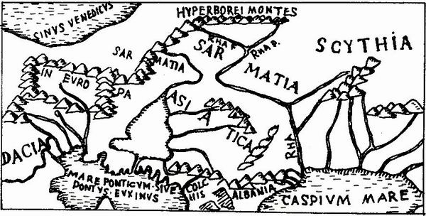
No doubt it is necessary to look once again at the ancient sources, especially since more and more researchers are convinced that the authors of antiquity must and should be believed. For instance, M.Agbunov, on the basis of paleographic data on changes in the Black Sea coastline, concludes that “the works of ancient authors are, as a rule, a reliable source and merit more attention and trust… it should be stressed that most of the concrete historical and geographical descriptions by ancient authors are absolutely correct.” In this case we can use such an authoritative source as Ptolcmaeo” Geography, especially since it is referred to by the authors of From Scythia to India and the author of The Ethnogeography of Scythia. But because the text, as we saw earlier, can be interpreted in different ways to prove contradictory conceptions, let us look at Ptolemaeos’ map, or rather at that part of Geography (published in Rome in 1490) where a mountain range is shown in the north and called Hyperborei Monies. This was the part in Ptolemaeos’ work that Bongard-Levin and Grantovsky called a mistake, claiming that Ptolemaeos put non-existent mountains in the north.
When we compare the map of the European part of the Soviet Union19 with Ptolemaeos’ map, we can see genuine geographical sites such as the Baltic, Black, Azov and Caspian seas, and the Volga running into the Caspian and called Rha*, the ancient Avesta name. We also see all the more or less significant elevated areas up to the Southern Urals, which are separated by a considerable distance from the Hyperborei Montes that Ptolemaeos marked in the north and that extend latitudinally, and that are the starting point of two sources of the holy river of the ancient Iranians-Rahi. This map indicates that Ptolemaeos, and probably geographers of antiquity long before him, make a distinction between the Hyperborei and the Ripei mountains, and the Urals.
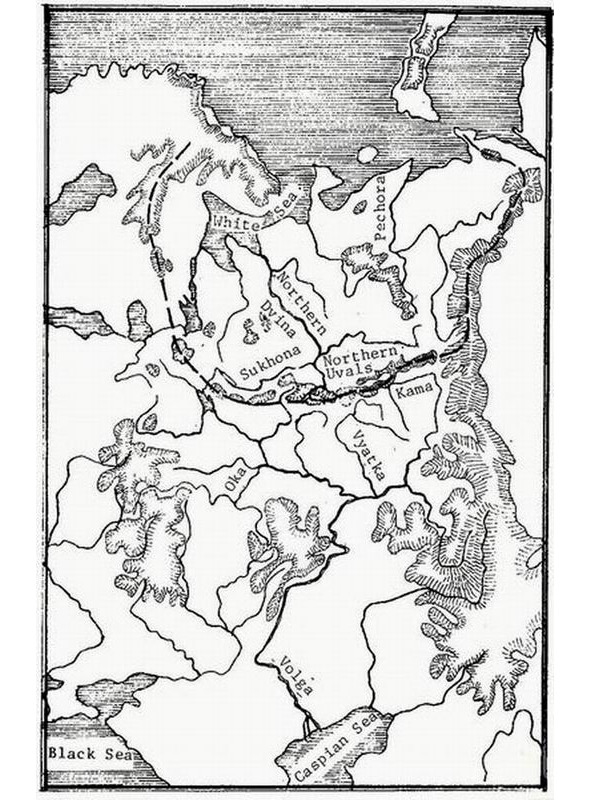
Was Ptolemaeos correct or incorrect, were there such elevations in the north that were the starting point of the Volga** and Kama rivers? The map of the USSR shows objectively that there were such elevations-the Northern Urals (Hills). Located in the northeastern European part of the Soviet Union they extend 1,700 kilometers from west to east, and through the Timan mountain ridge combine into a single system with the Northern Urals.
One of the Soviet Union’s most prominent geomorphologists, Yu. Meshcheryakov, wrote the following in his fundamental study, Relief of the USSR, published in 1972: “The world divide that borders the Arctic Ocean basin is farthest away from the ocean to the south, deep inside Eurasia, the Asian part of the USSR. The maximum distance from the ocean to the divide -3,000—3,500 kilometers — is marked on the meridians of Baikal-Yenisei… Going through the Urals, the dividing line suddenly approaches the coast, and within ike Northern Uvals it is only 600—800 kilometers from the shore”. The author goes on to say that the Northern Uvals are the main divide of northern and southern seas in the Russian plains. While he calls them the “principal orohydrographical anomaly of the Russian plains”, he notes the paradox that “the highest elevations (Middle Russia, Volga region) are in the southern part of the plains, they are not the main dividing lines, yielding the role to the insignificant, relatively small Northern Uvals.” Meshcheryakov also points out that unlike most of the Russian plains’ elevations which are oriented meridianally, “The origin of the inverse morphostructure of the Northern Uvals remains unclear. This elevation does not have a meridianal, but a sublatitudinal direction”.
He writes of a “close, organic tie between’ the undulating deformations of the Urals and Russian plains,” and stresses that "...the Timan mountain ridge starts from the orographical junction of the “Three Rocks” (Konzhakovsky Rock- 1,569 meters, Kosvinsky Rock-1,519 meters and Denezhkin Rock- 1,492 meters). This wide and elevated section of the Urals is on the same latitude as the Northern Uvals and joins them forming a single latitudinal elevated zone”.
The work also notes the same origin of the Northern Uvals, Galichskaya and Gryazovetsko-Danilovskaya elevations, or those latitudinal elevations in the northeastern European part of the Soviet Union that unite into a single bulge the elevations of Karelia, the Northern Uvals and Northern Ural mountains, that is, the part of the range that runs in a north-northeastern direction.
Thus, the Northern Uvals — the main divide of northern and southern rivers, the basins of the White and Caspian seas — are the precise location Ptolemaeos cited for the Hyperborei (or Ripei) Mountains, the source of the holy river-Rha.
However, according to the same Avesta tradition, its source is in the mountains of High Hara — Hara Berezaiti, on the “golden summit of Hukairya”. Of interest in this connection is what Al-Idrisi (12th century) wrote about the Kukaiya Mountains that he places in the far northeast of the oecumene and “that could be connected with the Ripei Mountains noted by ancient geographers, primarily Ptolemaeos”, 26 and the Hukairya Mountains of Avesta. Dwelling on the Kukaiya Mountains, the source of the Rusiya River, Al-Idrisi points out that: “Six big rivers flow into the aforementioned Rusiya River; their sources are in the Kukaiya Mountains. These are big mountains extending from the Black Sea to the edge of the inhabited Earth… They are very big mountains; no one can climb them because of the extremely cold weather and the constant abundance of snow on their peaks.”
If we accept the Ripei (Hyperborei) and Kukaiya mountains as the Northern Uvals, the six rivers are readily found. The Volga (Rusiya) is indeed the drainage point of six rivers that flow from the Uvals — the Kama, Vyatka, Vetluga, Unzha, Kostroma and Sheksna.* Thus, if we regard the Kama as the source of the Volga, as was the case in ancient tradition, then the Volga (Rha) of Ptolemaeos and Avesta, indeed, begins in the Northern Uvals (especially since the actual sources of the Volga are in the Valdai elevation which is included in the southern part of the bulge described). They are also the starting point of the biggest river in the Russian North — the great and deep Northern Dvina which runs into the White Sea and has over a thousand tributaries. One of them, the Emtsa River, does not freeze over in the winter due to the hot springs in its canyon.
The hymn of Ardvisura Anahita to the holy Avesta river has these lyrics:
3. “The large river, known afar, that is as large as the whole of the waters that run along the earth; that runs powerfully from the height Hukairya down to the sea Vouru-Kasha.
4. she, Ardvi Sura Anahita, who has a thousand cells and a thousand channels…
5. “From this river of mine alone flow all the waters that spread all over the seven Karshvares; this river of mine alone goes on bringing waters, both in summer and in winter.
In exalting the holy river flowing to the north into the Vourukasha Sea, the author of the hymn gives praise to those who bring it offerings on the “Hara summit,” on the “Hukairya summit” of the ancestors of the Aryans, Jima (Yama) and Paradatta.
In addition, the latitude of the Northern Uvals is 60° north and they are not only the principal divide of the Russian plains and the border between north and south, but the year there is divided into six light and six dark months. The North Star and Big Dipper there are high in the sky, and if you go down toward the sea you can also see the northern lights. A long winter is normal on these latitudes where the first snow is often in the latter half of September, and the last snow can be at the end of May, so that “the average period of safe growth of plants is equal to four months".Relevant here is Herodotus’ comment that “in all the countries named (by the Ripei Mountains) the winter is so harsh that hard frosts last eight months. During that time, even if you pour water on the ground there will be no mud, unless you light a fire… Such cold weather lasts in those countries an entire eight months, the other four months not being warm either”. Besides, it is interesting that the presence of hornless cattle in the Kirov and Perm districts confirms Herodotus’** comments about hornless bulls in the lands by the Ripei Mountains,33 which he believes is due to the harsh climate in these areas.
Turning once again to Indo-Iranian epic tradition, we should stress one more interesting detail: the hymns of Avesta, Rigveda and Mahabharata, authors of antiquity, and medieval Arab travellers all speak of riches of the Hara and Meru, Ripei (Hyperborei), and Kukaiya Mountains. Herodotus writes: “There is apparently very much gold in northern Europe. I cannot say for sure how it is extracted. According to legend, one-eyed Arimaspi people steal it from griffins.”
Is there any truth to stories about gold in the river beds, the countless treasures of these mountains if we regard the Northern Uvals as the legendary mountains? Let us look at reference literature. The Brokhaus and Efron encyclopedia says that the banks and river beds of the Mera, Volga (by Kostroma), Unzha and their tributaries have such an abundance of pyrites (fool’s gold) that it is enough lor industrial use. At the end of the 19th century peasants collected rock-ore washed up by the rivers and brought them to local factories.36 The Vurlam River flowing from the Northern Uvals to the south and its tributaries carry their waters through fields containing golden sand.
Relevant here is some information about the mineral resources of the Northern Uvals, the Timan mountain ridge, and other elevations in the northern European part of the Soviet Union. Many of them were most likely well known and used back in ancient times. They are sheet mica, mountain wax, tar, oilstone, rock salt, cuprous limestone, malachite, iron, copper, tin, silver, gold, precious stones such as diamond, zircon, ilmenite, spinel, amethyst, garnet, rock crystal, agate, beryl, chalcedony, amber. This list could be continued, but suffices to prove that the rivers flowing in “golden beds” and mountains “rich in precious stones” are not myths.
The mysterious holy mountains of Indo-Iranian mythology, Scythian legends and stories by ancient writers, begin to seem quite real as virtually everything said about Hara and Meru, the Ripei (Hyperborei) mountains applies to the Northern Uvals:
1. Like the legendary mountains, the Uvals extend from west to east.
2. Like these mountains, they are the border of the north and south, and are the main divide of rivers of the south and north that flow from the Uvals.
3. As in these mountains, the North Star and Big Dipper can be seen high in the sky all year.
4. As true of these mountains, the shores of the freezing White and Barents seas lie behind the Uvals. Here the polar day and the polar night are both half a year long. The northern lights can be seen on the sea shore.
5. There is only one place in the Soviet Union where the direction of the predominant air masses in the winter is clearly oriented from the northeast to the southwest. Starting out in the Kara Sea, running along the western extremity of the Northern Urals, and skimming over the Northern Uvals,40 this powerful current “is the same northeast wind invariably mentioned in connection with the Hyperborei and Ripei mountains and the related problems”.
6. Rivers flowing from the Northern Uvals do often have gold in, their beds, or beds lined with pyrite (fool’s gold) which resembles gold.
7. The Northern Uvals and the Timan mountain ridge are rich in a variety of minerals.
8. The Northern Uvals are covered with luxuriant forests and an endless variety of herbs and grasses. Fir, linden, elm, alder, and birch trees, black and red currants, Cornelian cherries, honeysuckle, rose hips, and thickets of hop grow on their slopes. These places have always been famous for abundance of animals, birds and fish: all this is mentioned in ancient and medieval literature as applied to the Ripei Mountains.
Among what has been said of holy mountains in the Indo-Iranians (the Ripei Mountains of the Scythians), and what we have not as yet linked with the Northern Uvals, there is another important detail — their altitude. Indeed, the Hara, Meru and Ripei mountains are described as very high, whereas the Northern Uvals today are no ' more than 500 meters above sea level. But it must be kept in mind that the singers of Mahabharata always described Hara and Meru as covered with forests and teeming with animals and birds.Consequently, they could not be very high.
Just what are the Northern Uvals like? Let us refer to E. Murzaev’s Dictionary of Folk Geographical Terms which says that an “Uval” (hill) in the vicinity of the White Sea is a steep and tall river bank, a mountainous ridge along a valley.44 The river valleys of the Northern Uvals divide are deep and steep canyons with sides up to 80 and more meters high. The Sukhona drop on the section from Totma its month is over 49m, here it is as rapid as a mountain river.45 We know the altitude of mountains is not stable — over the millennia elevation parameters change, they become bigger or smaller. According to geological data, the ancient river valleys of the divide were 80—160 meters lower than they are today. Researchers unanimously agree that deep-set ancient valleys were caused by vertical tectonic movements of relatively large amplitude — 200—400 m46. Hence, we cannot say with certainty how high the Northern Uvals were 3,000—5,000 years ago, that is3 in Indo-Iranian antiquity, whose lower level it is impossible to chronologies precisely.
Finally, the question of cradle of the Indo-Iranian peoples is still open. Most Soviet researchers link the formation of the Indo-Iranian group with the southern half of the European part of the Soviet Union — the reaches of the lower Don. the northern Black Sea and Volga areas, etc.47 In antiquity the Uvals were indeed located north of the sources of rivers flowing on these lands, and they blocked the way to the shores of the White and Barents seas, which is probably why the legends said the mountains were impassable.
There is one more point: precisely in the watershed section of the Northern Uvals, to this day, there are many place names of intriguing similarity to Indo-Iranian words: Harino, Harovo, Harina Mountain, Harenskoye, Harinskaya, Harinovskaya; Mandara, Man-darovo, Mandra (and the Mandara mountain in the Mahabharata); Ripino, Ripinka, Ripa (and Ripei Mountains), etc. Just as interesting are river names in the region, names of still unknown origin: Indola, Indomanka, Indocap, Sindosh, Varna, Striga, Svaga, Svatka, Hvarze-nta, Harina, Pana, Kobra, Tora, Arza. (To the best’ of the author’s knowledge the possible connection between the hydronyms of this area and Indo-Iranian languages has not yet been studied). Besides, as late as the early 20th century the weaving and embroidery designs used by Russian peasant women still preserved the tradition of geometric ornamentation which originated in the most ancient Eurasian cultures of the Copper and Bronze ages, and primarily in the ceramic ornamentation of the Andronovo farming-stock breeding culture of the 17th-12th centuries B.C. which many researchers believe was an Indo-Iranian (Aryan) group.
Ah this gives reason to surmise that the holy mountains of Hara and Meru in Indo-Iranian mythology, the Hyperborei and Ripei Mountains mentioned by the Scythians and authors of antiquity, were the elevations of the northeastern European part of the Soviet Union — the Northern Uvals.
In conclusion, the Northern Uvals, especially in their eastern and central regions, remain practically unexplored by archeologists.
Hopefully, in the near future they can expect new and fascinating discoveries helping to raise the curtain covering the history of many peoples inhabiting our continent.
Where are you, Mount Meru?
In the far north, where the land is covered with snow most of the year, great and endless mountains stretch from west to east. Around their golden peaks, the sun makes its annual journey, seven stars of Ursa Major sparkle above them in the dark of night, and in the center of the universe is the North Star. From these mountains all the great earthly streams rush down, only one of them flows south, to the warm sea, and others — to the north, to the white ocean. On the tops of these mountains forests make noise, marvelous birds sing, wonderful animals live and rivers flow in the golden channels. But it wasn’t given to a mere mortal to ascend upon them, only the most daring and wise ones transgressed the limit set for people and left forever in a blessed country, the shores of which were washed by the waters of the dairy ocean. The mountains that separate the north and the “white” sea from all other lands are called the Meru Mountains, and the greatest of them is Mandara. Over the mountains Meru lasts six months day and six months — night, there the waters freeze, taking on a bizarre shape, there, in the sky above the ocean, rainbow-colored water drops sparkle, and only birds and great sages — “rishis” know the way to this land. This is the story of the distant northern country, of the ancient ancestral home of the Vedas hymns — the oldest sacred monument of the Indians. A strange, unexpected tale, it is not clear how it was born in distant, hot India, this story would have sounded if it had not lived among the most ancient legends of another southern country — Iran.
The Avesta, the sacred monument of the Iranian peoples, in its most ancient part Bundakhishna, which tells about the creation of the world, also tells about the distant northern ancestral home of the Iranians — the land of gods and ancestors, where the ranges of High Hara — Hara Berezaiti stretch from west to east with their main peak mountain Hukayrya. And above High Hara also seven stars of the Big Dipper and the North Star, set in the center of the universe, sparkle. From here, from the golden peaks originate, all the earthly rivers and the greatest of them are the pure Ardvi River, flowing with a noise into the white sea of Vourukash. Over the mountains of Vysokaya Khara, the Rapid Sun is always circling, and half a day lasts here for a year, and half a year — night. Only the brave and strong in spirit can pass these mountains and get into the happy country of the blessed, washed by the waters of the white-fronted ocean. Again these fabulous golden mountains, covered with dense forests, where the sacred plant of catfish, or haoma, grows, and from which violent rivers flow down in the golden channels. Where, how, when did the Indians and Iranians learn about the countries of cold and snow, freezing waters and the northern lights? When and where were you able to see the North Star high above your head? Scientists have been asking these questions for a century now. At the beginning of the 20th century, a book by Bal Gangadhar Tilak “The Arctic Homeland in the Vedas” appeared. He believed that the ancestors of the Indians lived in the Arctic, from where, in the 8—6 millennium BC, they left to the south under the influence of the onset of cold weather.
More than 100 years have passed since the publication of the book of Tilak, and the debate about where the Indians’ ancestral home was, where the sacred mountains eru and Hara Berezaiti rise, do not stop. But today, most scientists have come to the conclusion that the Indo-Iranian (Aryan) community was formed somewhere in the southern Russian steppes in the third — beginning of the second millennium BC. Soviet researcher B.V. Hornung suggested that the “cradle of Indo-Iranian linguistic and cultural-historical unity” was in the Middle Volga.
Scientists now know that the ancient Indo-Iranians (Aryans) were farmers and pastoralists, they sowed bread, grazed cattle and, settling in ever wider spaces, moved to the east, and west, and north, and south. And somewhere exactly in the north of their ancestral home there should have been those very sacred mountains that sang the hymns of the Avesta and the Rig Veda. But where? Ancient Greek authors also wrote about the great northern mountains, who believed that these mountains, which they called the Riphean Mountains, occupied the entire north of Europe and were the northern border of Great Scythia. So they were depicted on one of the first maps of the earth — a map of the 6th century BC Hecateus of Miletus. Herodotus wrote about the distant Northern Mountains stretching from west to east. Doubting the incredible, fantastic magnitude of the Riphean Mountains, Aristotle, nonetheless, believed in their existence and was convinced that it was from these mountains that all the largest rivers of Europe flow accept the Istros — Danubes. Behind the Riphean Mountains, in the north of Europe, the ancient Greek and Roman geographers placed the Great Northern, or Scythian, ocean.
But where exactly are the Northern Mountains — this question remains open to this day. Perhaps the creators of ancient Aryan hymns sang these ridges of the Urals, as well-known Soviet scholars G.M.Bongard-Levin and E.A. Grantovsky think? Indeed, the Ural Mountains are located in the north with respect to India and Iran; they are rich in gold and gems and stretch far to the freezing North Sea.
Yes, only the Avesta, the Veda, and ancient historians constantly repeat that the great mountains stretched from west to east, divided the land to the north and south, and the Urals — this is the border of west and east. And, finally, neither the Don, nor the Dnieper, nor the Volga originates from the Ural Mountains, and the sacred river Ardvi, flowing into the “white ocean”, is difficult to find on the spurs of the Urals. He does not divide the “earthly waters” into those that flow to the south, and those that rush to the north. But this is a distinguishing feature of the Meru Mountains and High Hara. Or did the ancient Aryans mix up east and west with north and south in their travels? Unlikely! They knew geography for their time very well, and it was more than difficult to frighten the sides of sunrise and sunset. And if neither the Veda singers, nor the creators of the Avesta, nor the ancient authors were mistaken, and did these mountains really exist in northern Europe, stretching like a bow curved towards the south, from west to east? And, probably, they have not gone anywhere in the 3—4 thousand years that separate us from the time when the ancient Aryans began their journey to India and Iran. And one thing remains — a little closer look at the map of our homeland. Here is the Black, Azov and Caspian Seas, steppes scorched by the sun; great rivers flow here from the north — the Dnieper, Don, Volga. And here is the north of the European part of the country. Cold and inhospitable White and Barents Seas, Arctic Ocean.
Many rivers flow here from south to north and among them the mighty, full-flowing Northern Dvina, which flows into the White Sea. The vast East European Plain is replete with elevations: Central Russian, Valdai, Volga… Among them, the arc consisting of the mountains of the Kola Peninsula, small elevations of the west of the Vologda Region does not immediately catch the eye. Northern Uvals and the Northern Urals, stretching from west to east for 3,700 kilometers and really separating the coast of the White and Barents Seas from the rest of Europe.
Part of this huge arc, and a very significant one, are the Northern Uvals, reaching two thousand kilometers from the west to the east, and reaching the Northern Urals. They are not high; the highest point here is only 293 meters above sea level. Of course, not the Pamir, not the Himalayas, but… it is here that the watershed of the rivers of the Caspian and White Seas is located. It is here, on the Northern Uvals, that the south of Unzha and Vetluga, the Kama and Vyatka, the rivers of the Great Volga basin, begin, and only a few kilometers from them begins its rapid movement north, to the White Sea, the South river, which merges with River Sukhona, forms the Small Northern Dvina. The second major watershed section also fits into the arc of the North Russian Uplands. This is the area of the White Lake, where the source of the high-water Sheksna flowing south, and Onega and Sukhona to the White Sea.
What is the Northern Uvals? “Damn… In the area of the White Sea,” as stated in the “Dictionary of Popular Geographic Terms” by E. M. Murzaev, “the steep and high coast of the river, mountainous ridge accompanying the valley.”
On the watershed section of the Northern Uvals, where the mountains seem to cut the rivers into southern and northern, the river valleys are deep, up to 80 meters or more canyons with steep banks. The Sukhona River (part of the small Northern Dvina) on the stretch from the city of Tot’ma to the mouth resembles a mountain river with its swiftness, because its fall here exceeds 49 meters, and in the vicinity of the village of Opoki, the banks height exceeds 80 meters. Sukhona has about 130 tributaries. The channels of the rivers flowing in the regions of the Northern Uvals are usually lined with pure orange-yellow micaceous sand, and the high steep banks surrounding them are made of orange mica sand, bright red plastic clay, red coarse-grained and yellow sandstone. How not to be born here the legends of rivers flowing in the “golden” channels, among the “golden” mountains!
Of course, they may object: “How is it, because the mountains Meru and Hara Berezaiti are Great, the highest in the world, higher than the sky and even higher than the sun, and here are some 293 meters?” This is probably due to the fact that when a person leaves the homeland, its image — where the brightest sun, the greenest grasses, the cleanest rivers and the highest mountains — lives in legends and songs. Century after century, those from the Aryans who then were to become part of the great peoples of India and Iran went farther south-east. They met on their way the highest mountains of the world, and the image of the Great Mountains of the land of their ancestors was painted with new colors. High Hara and Meru, sung by the forefathers in their sacred hymns, of course, could not be lower than the Pamirs and the Himalayas, they should have been the highest in the world, higher than the sun.
But remember: in the hymns of the Vedas and in the Avesta, the peaks of these mountains are covered with dense forests, where wonderful birds sing, where various animals live, where a wonderful hopping haoma-soma grows. It turns out that there were not so high forested areas inhabited by the beast and bird Meru and High Khara. And what about the Northern Uvals? Three quarters of them are covered with forests. And what forests! Here and spruce, and fir, and linden, and maple, and elm, and elm, and bird cherry, and alder, and birch, and aspen, and even oaks. It is at 60 degrees north latitude! Various shrubs grow in these places: red and black currants, dogrose, dogwood, honeysuckle, viburnum and hops in abundance. And in the forest meadows — magnificent forbs. As early as the beginning of the 20th century, these places were famous as rich hunting grounds, abundant in animals, birds, and fish. But it is in the summer. In winter, a snowstorm sweeps, a piercing northeast wind howls on the northern slopes of Uvals, whirls, covering everything around with flakes of snow, a blizzard. It turns out that the Aryans carried away in their new hot homeland the memory of the merciless, deadly north wind — Vayu, reigning on the slopes of the Meru Mountains. But before those who, having won the battle with the winds and snow, overcame this mountain barrier, the vast expanses of the sea opened up, fantastically frozen waters, and sparkled in their honor, illuminating the path further, the light of the northern lights.
The memory of the mountains lives in the hymns of the Veda and the lines of the Avesta, in the names of the villages and villages of the Russian North. Listen to them: Mandara — Mandarovo, Mundora — Mundorka and Mount Mandara “Vedas”; Harino — Harovo, Kharachevo — Harinskaya, Harlovo — Kharapikha, Kharkhorino — Harionovo and High Hara Avesta; Ripino — Ripinka, Ripina, Ripa and the Riphean mountains of the ancient Greeks. And also Svyatogorye, Semigorye and many villages and villages with the names of Gora (mountain) or Gorka (slide). Dvina flows into the White Sea. Or is it just a consonance of Dvina — Ardvi? Or maybe not? After all, the residents of the Kharovsky district, where the Kharovsky ridge stretches, call sand the strange word “hara”. In Sanskrit (Indo-Iranian language), “hara” is yellow, golden, orange, reddish, sunny…
Several years ago, teachers of the Russian language from around the world came to the ancient Russian city of Vologda from the University of Peoples’ Friendship named after Patrice Lumumba. And in the museum halls, looking at the patterns of embroidery and weaving made at the turn of the 19th and 20th centuries by North Russian peasant women, the young Indian said in surprise: “There is almost nothing new for me here. All this I have seen many times at home. But that shocked me the most. Explain how our embroideries could get to you?”.
The Russian North is the sacred ancestral home of the Aryans!
“The discovery of Zharnikova” — this is how modern scholars call the theory, which is proved by the candidate of historical sciences, art critic, who lives and teaches in Vologda, Svetlana Vasilyevna Zharnikova. The author of monographs and articles on the history and art of the Russian North, she is firmly convinced that in ancient time, different processes took place in the northern Polar Regions than those described by orthodox science. We asked about this and much more today the author of the discovery.
— Svetlana Vasilievna, tell us what the essence of the enormous research that you conducted is and what it crowned with!
— First, a little from the history of the issue. The fact is that the polar theory of the formation of human civilization appeared long ago, back in the nineteenth century. At the beginning of the twentieth century, the first serious studies on this topic appeared, for example, in 1903, the Indian scientist Tilak wrote his book “The Arctic Homeland in the Vedas”. Long-term studies of the Indian and Iranian holy books of the Vedas and Avesta led him to a startling conclusion: the homeland of the ancestors of the Indo-Iranians or, as they were called, Aryans was in northern Europe, somewhere near the Arctic Circle. A little later, the Russian scientist Jelachich published his book: “The Far North as the birthplace of mankind.” In it, he, in fact, deepened and developed Tilak’s ideas. The stumbling block of historians’ disputes was the question: where were the original lands of the Aryans, where is their ancestral home.
Among the amazing phenomena of the land of the Aryans described in the Vedas and Avesta, there is one extremely important one — the sacred mountains of the ancestral home of the Aryans: Meru — in Indian traditions, Hara — in Iranian.
These mountains were also described by the Greeks, they called them Hyperborean, all the largest rivers of Europe flowed from them, and the Scythian ocean lay behind them. In order to reach the world of the gods, it was necessary to overcome the great and endless mountains that stretched from West to East… seven stars of the Big Dipper and the still-located star of Dhruva sparkle over them in the darkness. All the great rivers began from these mountains, only some flow south to the warm sea, while others flow north to the “white ocean”.
What do we see? The constellation Ursa Major and the Pole Star “in the center of the universe” sparkles above the ancient mountains of Arya, and based on the text of the Avesta, “the fast-moving sun” always circulates over the mountains of the great Hara. In the hymns of the Rigveda and Avesta, it is said that in the homeland of the Aryans “six days a day and six months a night”.
Given some evidence, forgetting about the others, it was believed that the Vedas and Avesta describe the Ural Mountains, but the Urals are oriented from south to north, and all sources claimed that these mountains stretch from west to east. Meanwhile, the circumpolar Urals has a northeastern orientation. Here, from the so-called “Three Stones”, the Timan Ridge departs, which combines with the Northern Uvals, which are the main watersheds of the northern and southern seas.
It is here that one should look for the sacred ancestral home of the Aryans, it is here that the earthly waters are divided into streams flowing into the “white sea” of the north and flowing south.
There is a hymn in the Avesta, glorifying the ancient river of the Aryans of Ardvi-Suru, which flows into the North Sea. Some historians believed that this was the Amu Darya, but this river is always muddy, while the ancient Aryan river is said to be transparent, pure and healing. Others believe that this is the Volga.
There is a reason for this: latitude, vast delta and beginning in the high mountains.
I managed to prove that we are talking about the Northern Dvina. Firstly, its upper part is formed from two rivers of the South and Sukhona: hence the names Dvina, that is, “double”. The name “Ardvi” is also translated. The Volga has many tributaries, but the merger of two streams into one does not create this river.
Secondly, in box 5 in the Avesta, a strange phenomenon is mentioned: along with a description of the frost, snow and hail that feed the waters of Ardvi-Sura, one channel is mentioned: “it flows seven Karshavars, flowing evenly in summer and winter.” The Volga does not have a channel that would not freeze in the winter, but the Northern Dvina has it — it is the Yemtsa River, from its bottom all year round sources that are called “kipuns” beat. This is one of the major tributaries of the Dvina. Yes, this is a discovery, and quite serious in our science, since now we do not suppose, but know where the sacred ancestral home of the Aryans was located.
— Svetlana Vasilievna, who, then, was our ancestors!
— The initial population of the Russian North was not Finno-Ugric, but Indo-European, speaking the Indo-European language, preserving the culture and rites of this people, preserving precisely this anthropological type. The most ancient books of the Vedas were written, transmitted orally in these northern, circumpolar territories. On this territory, say, conditionally, not Slavs lived; people lived here, speaking some kind of archaic form of Indo-Iranian languages.
Compare at least the Russian language and Sanskrit:
Russian — Sanskrit
matheri (mother) — matheri
syn (son) — suna
snuha (daughter-in-law) — snusha
nas (us) — nas
wam (you) — wam
dwa, dwe (two) — dwa, dwi
padati (fall) — pad
deva (virgin) — devi
The list goes on and on.
— Svetlana Vasilievna, historical science is replete with errors and examples of wrong paths. Do you know what you are saying, or do you believe in it?
— It is difficult to even capture the amount and variety of evidence that we apply. This is anthropology, and climatology, and linguistics, cultural studies… rituals. Indeed, if only in the North and in India it is customary for a dying man to end his life on straw, if both here and there the child is sheared a year old and his hair is surely rolled up in manure — this already says something.
And the names of our northern rivers! This is all the same ancient Indian, Sanskrit names! So, for example, in our region there are several Ganges Rivers. In the Ust-Sysolsk uyezd, the Gar river is “sprayed” in Sanskrit, and the Giridaya river is “given mountains” in the same place. Indoga River — in Sanskrit “Indu” — a drop of moisture. In the Velsk County, the Kala River is from the same language “dark, quiet”. In the Solvychegodsk district, the Lala river, according to Sanskrit, “Lal” — to play. In the Kirillov district there is Lake Swar, which means “sparkle”. There are hundreds of examples.
— And the last. The whole complex of your theory, all the fullness of evidence would not fit in several issues of the Russian North. Where can I find out more about your discovery!
— From time to time I give lectures at the Institute for Advanced Studies, in addition, the book “Antiquity: Aryans. Slavs”, there is my article there.
Where did the Drevlyans and Krivichi disappear, or why does the Vologda dialect in Sanskrit not need translation
A professor from India, who arrived in Vologda and did not know the Russian language, a week later refused a translator. “I myself understand enough Vologda,” he said, “because they speak spoiled Sanskrit.”
The Vologda ethnographer Svetlana Zharnikova was not at all surprised: “The present Indians and Slavs had one ancestral home and one proto-language — Sanskrit,” says Svetlana Vasilievna. — Our distant ancestors lived in Eastern Europe on the territory from about modern Vologda to the coast of the Arctic Ocean.
Svetlana Zharnikova wrote a monograph on the historical roots of North Russian folk culture. The book was thick.
Researcher of the ancient Indian epos Tilak in 1903 published his book “The Arctic Homeland in the Vedas” in Bombay. According to Tilak, the Vedas, created more than three thousand years ago, tell about the life of his distant ancestors near the Arctic Ocean. They describe endless summer days and winter nights, the North Star and the northern lights.
The ancient Indian texts tell that in the ancestral home, where there are many forests and lakes, there are sacred mountains that divide the land to the north and south, and the rivers to the current to the north and the current to the south. The river flowing into the southern sea is called Rga (or Ra, this is the Volga). And the one that flows into the Milky or White Sea is Dvina (which means “double” in Sanskrit). The Northern Dvina does not really have its source — it arises from the confluence of two rivers: the South and Sukhona. And the sacred mountains from the ancient Indian epic are very similar in description to the main watershed of Eastern Europe — the Northern Uvals, this giant arc from the hills, which ran from Valdai to the north-east to the polar Urals.
Judging by the studies of paleoclimatologists, in those days, which are described by the Vedas, the average winter temperature on the coast of the Arctic Ocean was 12 degrees higher than now. And it lived in the sense of climate no worse than it is now in the Atlantic areas of Western Europe.
“The vast majority of the names of our rivers can be simply translated from Sanskrit without distorting the language,” says Svetlana Zharnikova.
— Sukhona means “easily overcomeable”, Kubena means “meandering”, Suda means “stream”, Darida means “giving water”, Padma means “lotus, water lily”, Kusha means “sedge”, Syamzhena means “uniting people”. In the Vologda and Arkhangelsk regions, many rivers, lakes and streams are called the Ganges, Shiva, Indiga, Indosat, Sindoshka, Indomanka. In my book, thirty pages are occupied by these Sanskrit names. And such names can be preserved only in the case — and this is already the law — if the people who gave these names are preserved. And if it disappears, then the names change.
The year before last, Svetlana Zharnikova accompanied the Indian folk ensemble on a trip to Sukhon. The head of this ensemble, Ms. Mihra, was shocked by the ornaments on Vologda national costumes. “These, she exclaimed enthusiastically, are found here in Rajasthan, and such in Aris, and these ornaments are just like in Bengal.” It turned out that even the technology of embroidery of ornaments is called the same in the Vologda region and in India. Our craftswomen speak of the embossed smooth surface “chekan”, and Indian — “chikan”.
The cooling caused a significant part of the Indo-European tribes to seek new, more favorable living areas in the west and south. The “Deichi” tribes left for Central Europe from the Pechora River (Daitia), the “Suehan” from the Sukhona River, and the “Vagan” from Vagi. All these are the ancestors of the Germans.
Other tribes settled on the Mediterranean coast of Europe, reached the Atlantic Ocean. They went to the Caucasus and further south. Among those who came to the Hindustan peninsula were the Krivi and Drava tribes — remember the Slavic Krivichi and Drevlyans.
According to Svetlana Zharnikova, at the turn of the 4th-3rd millennia BC, the original Indo-European community of tribes began to break up into ten language groups, which became the ancestors of all modern Russians, Slavs, all Roman and German peoples of Western Europe, Albanians, Greeks, Ossetians, Armenians, Tajiks, Iranians, Indians, Latvians and Lithuanians. “We are going through a ridiculous time,” says Svetlana Vasilievna, “when ignorant politicians try to make nations alien to each other.” A wild idea. No one is better or older than the other, because everything is from one root.
Unfortunately, the book of the ethnographer Zharnikova exists in a single copy. Handwritten. There is no money in the Russian Federation for its publication. And Russia comes from “Rus”, which in Sanskrit means “holy, bright.”
Was there a sensation?
The newspaper “Rush Hour” (December 2, 1997) reported that the Moscow State University expedition, led by Ph. D. Valery Demin, discovered on the Kola Peninsula the “ancestral home of all terrestrial civilization” — the legendary Hyperborea, or rather, the remains of “ancient cult and scientific complexes, plates the correct form with traces of technogenic influence “and the ruins of an ancient observatory. It was also noted that the expedition members came to the sensational conclusion: “Hyperborea not only actually existed, but also was located on the territory of the Russian North.”
I would like to dwell on this last report, since we are talking about as much and as much about a very serious scientific discovery, the authorship of which allegedly belongs to the expedition members. Archaeological finds, of course, are bright and interesting, one cannot argue with this. But as for the sensational conclusion about the whereabouts of the “Legendary Hyperborea in the Russian North”, there is something to be surprised about. We must pay tribute to the staff of the editorial office of “Hour PIC”, the newspaper simply reprinted information from a selection of international agencies. And it’s not her fault that the employees of international agencies of our Russian magazines do not read, and apparently they don’t get involved in scientific periodicals either. Otherwise, they would have known that as early as 1903 a book by the outstanding Indian scientist and political figure B. G. Tilak “The Arctic Homeland in the Vedas” (translated to all European languages except Russian) was published. And even then, at the very beginning of the 20th century, Tilak declared — the legendary ancestral home of the Aryans (the distant ancestors of the Indians and Iranians) or the land that the ancient Greeks called Hyperborea, was in northern Europe, somewhere near the Arctic Circle, in the Arctic. He believed that it was here that the most ancient texts of the Rigveda and Avesta, the sacred books of the Indo-Europeans, were created. Following Tilak, the same idea was expressed by the Russian scientist E. Jelachich, who published in 1910 in St. Petersburg his book “The Far North as the Homeland of Humanity”. So the conclusion about Hyperborea in the Far North of Europe was made long ago. It is worth recalling that it was on the shores of the Arctic Ocean, which they called Kronius, that the ancient Greeks placed it.
The only thing that Tilak, Jelacich, and many other researchers did not — no one could specifically indicate where, the borders of this Hyperborean land passed. Everyone stopped before one paradoxical fact. Both the ancient Indian texts, and the ancient Iranian Avesta, and ancient Greek authors noted that the southern border of the legendary country was mountains, stretching in an arc from west to east and dividing rivers into currents flowing north into the Milky Sea, or the Arctic Ocean, and flowing south into the warm sea. These mountains were searched everywhere in Europe, and the most desperate traveled to Asia.
And one after another, assumptions were born. “Maybe these are the ridges of the Urals?” — said one. “Not! — answered others. — The Urals stretches from south to north and not from west to east. It does not start all the largest rivers (except the Danube), flowing through Eastern Europe. And then the Urals does not divide them into current north and south.” “But maybe this is the Tien-Shan? After all, it is located north of India, stretching from west to east. Is the Syr-Darya originating here and is the watershed of the rivers of Central Asia here? “Others asked. And they heard in response from their opponents: “No! Although the Syr-Darya begins here and flows into the Aral Sea, it cannot be called the Arctic Ocean. No one here has ever seen the northern lights, and the Polar Star and Ursa Major at its zenith also did not have to be observed. But these are the distinctive features of the latitudes, on which were the Hyperborean, Riphean Mountains (or Meru and Hara among the ancient Aryans). In addition, all the other rivers of Central Asia, flowing both north and south, do not carry their waters to any seas.”
The discussion ended with almost nothing, and in the early 80s it was decided to consider that the main geographical landmark of the land of Hyperborea is a myth, a retelling of the information received by the peoples living in the southern Russian steppes from the indigenous population of Siberia. And those, in turn, confused the direction of the cardinal points, and the Urals in them stretched not from north to south, but from west to east. They decided on that.
They were in no hurry to search for Hyperborea beyond the Ural Range, on the coast of the Arctic Ocean.
It would seem that you can calm down. But I, like many other researchers, have always been amazed by the fact that the sacred northern mountains were described too realistically in these myths too realistically. There are auroras, and convenient bays of the Milk Sea, and the sacred double river flowing into this sea, and the steep striped banks of the rivers, and the constellations of not only the Arctic, but also the Arctic, and much more, which is hardly necessary for the myth. I really wanted to find these mountains. And somehow, reflecting on the physical map of the European part of Russia, I paid attention to the light brown spots of the hills, stretching from west to east throughout the Russian North.
They really were similar in shape to a bow bent towards the south, and the ends of this bow were the mountains of the Kola Peninsula and the Subpolar Urals. A thought flashed: but it is precisely in the way that the bow bent to the south describes the sacred northern mountains, the Hyperborean mountains of the ancient Greeks in ancient texts. What was my amazement when it turned out that it was here that the main watershed of the rivers of the Russian Plain is located, i.e. indeed, these elevations divide the rivers into those flowing into the White Sea and flowing into the Caspian Sea.
The outstanding geomorphologist Yu. A. Meshcheryakov, in his book Relief of the USSR, wrote: “The position of the main watershed of the northern and southern seas on the Russian Plain belongs to the Northern Uvals”. It was they who caught my eye when considering the map on that memorable day of 1986.
And then facts began to gather, confirming that the mysterious Hyperborean mountains, the sacred mountains of the Arctic ancestral home of the Aryans, were indeed found. So, on the map of Ptolemy (2nd century A.D.), the Ripey (Hyperborean) mountains were in the ancient degree grid exactly where the Northern Uvals are located, at 60—63° N. It is from here that the Kama originates, which the ancients considered the source of the Volga — Ra. And the Valdai Upland, from where our great river really begins, also enters the southern part of this arc of hills. From here from the Northern Uvals, the greatest river of the Russian North Dvina (which means “double”) originates, which flows into the White (“Milk”) sea, which has convenient bays. The facts confirming that the conjecture was correct accumulated at the speed of a snowball.
There were no more doubts.
In 1986, that is, eleven years ago, all these conclusions were presented in the article “On the possible localization of the sacred mountains of Meru and Hara of Indo-Iranian (Aryan) mythology”, which was published in one of the scientific publications of UNESCO “Newsletter International Association for the Study of Cultures of Central Asia” (Issue 11). A map was attached to the article, on which the outlines of the Hyperborean mountains of ancient myths and, accordingly, the borders of the legendary Hyperborea were determined. In 1987, the magazine Around the World published a second article on the same topic, “Where are you, Mount Meru?”
At the end of a 1986 article, the author wrote: “I would like to note that the areas of the Northern Uvals, especially in their eastern and central parts, are hardly archaeologically explored today, and it is hoped that new interesting discoveries and discoveries are awaiting here in the near future “allowing to lift the veil over the past of many peoples inhabiting our continent.”
So it’s worth sincerely congratulating the expedition of Valery Demin on wonderful findings. But at the same time, note that the expedition went to the Kola Peninsula quite consciously and knew what it wanted to find. The path was indicated to her back in 1986, when the conclusion was first made: Hyperborea not only actually existed, but also was located in the Russian North. And do not be surprised at the fact that the expedition found grapevine vines beyond the Arctic Circle. Indeed, in 5—3 thousand BC the climate here was different, and average summer temperatures were higher than today by 3—5°C. That in the presence of constant summer sunlight really turned these lands into an earthly paradise.
Polar Homeland
Russia to Russia
How old is humanity? Modern scientists, as a rule, call the figure 40 thousand years — from the moment the Cro-Magnon appeared on Earth. This is the standard time interval allotted to human history in educational, scientific and reference books.
However, there are other figures that do not fit into the framework of officialdom. 400 thousand years — this date was calculated by ancient historians — Chaldean, Egyptian, Greek, and was projected onto Russia by Lomonosov.
(In fact, in the scale of events in world history there is another clearly fixed date that the imagination of modern people is not able to contain: according to the scrupulous calculations of astronomers and priests of the ancient Mayans, the history of mankind began in 5041738 BC.).
The Great Russian Lomonosov, a native of the Russian North, was always worried about why “in the northern parts of the ancient eyelids there were great heats where elephants could be born and multiply… it was possible.”
The answer was unequivocal: the cause of the catastrophic cooling that once covered the Russian North was the displacement of the earth’s axis and the change in the location of the poles. This happened about 400 thousand years ago, which is consistent with the calculations of the Babylonian astronomers and Egyptian priests.
The news of the “doomsday” was preserved in the legends of most ancient peoples — from China to America, and Plato directly wrote about the era when the Sun rose in the West and set in the East, but then everything became the other way around (which is possible only as a result of the revolution of the earth’s axis).
There are at least three possible options for the pole shift, which entails climatic cataclysms.
Option one: the earth’s surface moves after the shifting axis.
Option two: the earth’s axis changes its inclination, but the position of the globe in relation to the plane of the ecliptic remains the same.
The third option: the North and South magnetic poles interchange, which, as is known, do not coincide with the geographical ones (geomagnetic inversion).
There are even more possible reasons for the past universal cataclysm. The most commonly referred to is some kind of cosmic anomaly: a supernova burst or the appearance of an ordinary star in relative proximity to the solar system, the collision of the Earth with a comet or other celestial object, imbalance or rearrangement of planets in the family of the sun, approaching the moon, etc. All this inevitably entailed catastrophic consequences for earthly inhabitants.
The memory of world cataclysms has been preserved in the ancient legends of the majority of the peoples of the earth. The universal catastrophe is impressively portrayed, in particular, in the Saami epos.
According to the Saami cosmogonic legend, “when human anger intensified,” the center of the earth “trembled with horror, so that the upper layers of the earth failed, and many people fell into these caves to die there.” And Yumbel, the supreme heavenly God, came down to earth…
An angry God said: “I will turn this world upside down. I will make the rivers flow back; I will make the sea gather in a huge wall, like a tower, which I will bring down on your evil earthly children and in this way destroy them and all my life.”
Yumbel caused a blowing gale and enraged air spirits…
Foamed, fast, rising to the sky came the sea wall, crushing everything.
Yumbel with one strong blow made the earth roll over; then he leveled the world again.
In the Lapland epic, the world was destroyed by a hurricane and the sea, and almost all people died. After the sea wall collapsed onto the continent, giant waves continued to roll and dead bodies swiftly rushed along the surface of dark waters.
The initial Russian chronicle, if you look deeply, also counts down from such an event. The very first phrase of Nestorov’s annals (after the well-known beginning of “This story of time years…") answers the question “Where did the Russian land come from?” And begins with the words “after the flood” — “after the flood”, that is, after cataclysm, the reasons for which were pondered by Herodotus, Plato, Diodorus of Sicily, Lomonosov and others.
In this sense, the roots of the name of Russia and the ethnonym “Russian” can be found in the language of the ancient Aryans — the ancestors of all modern Indo-European peoples.
In Sanskrit, the word “Rusa” has the same meaning as in the Slavic and Old Russian languages, namely: light brown, light (shade). If we open the dictionary of Vladimir Dahl to the word “Rusi”, we find there a similar explanation: “Rusi”, according to Dahl, means, first of all, peace, white light, and the phrase “in Rusia” means in plain sight.
But the Aryans also had great ancestors that lived in the Far North before the onset of cooling. The history of all the peoples of the Earth goes back to a single prana people with a single parent language. The symbol of this polar ancestral home in many ancient cultures is the universal Mount Meru, located at the North Pole.
From its name came a whole nest of modern Russian words: “mir” in its three main senses — “Universe”, “people”, “consent”, as well as “mera (measure)”, “more (sea)”, “mor (pestilence)”, “moroz (frost)” and others. Another historical landmark for the northern prehistory is the legendary country of Hyperborea.
However, to continue the further excursion into the history some general remarks are necessary.
Does ignorance rule the ball?
From the time of the militant Russophobian-Normanists of the 18th-19th centuries, a point of view distant from science has been implanted in historical literature, according to which Russian history itself begins supposedly with the calling of the Varangian princes, as well as with the adoption of Christianity that soon followed. Until then, the Russian people stayed, they say, in a wild, barbaric state, not to mention the fact that Slavic tribes in general are aliens in the territory where they live at the moment.
Unfortunately, N. M. Karamzin, who set the tone in his “History of the Russian State” with the following melancholic phrase: “This great part of Europe and Asia, now called Russia, in its temperate climates, helped to strengthen data far from reality of ideas, unfortunately. “It was originally inhabited by wild, inland ignorant peoples who did not celebrate their existence by any of their own historical monuments.”
Denial of the originality and autochthonism of the ancient Russian culture, but essentially the rejection of the most ancient roots of the Russian people and the establishment of the boundary of its historical existence sometime in the 9th century A.D. (some reduce this restrictive bar to 4—6 centuries) it was beneficial for both the then official authorities and church representatives.
The former were not interested in anything outside the framework of state legal structures, and their appearance was unambiguously associated with the appearance of the first ruling dynasty of the Rurikovich.
The latter was more than satisfied with the thesis about the savagery of the morals and culture of Russian people before the adoption of a new religion.
Unfortunately, this position, in every possible way encouraged and cultivated, has survived to the present day and has occupied a dominant position in school and university textbooks, scientific and popular literature, in the media, etc.
As a result, the opinion is widely spread that up to certain (specified) time limits, the Russian people did not exist at all, being outside the historical state, and when they arose (seemingly from nonexistence) in the historical arena, they simply adopted ideology, culture and state-legal traditions that developed before him (in the West) and without him.
Fortunately, another stream was always strong in Russian historical science.
Many prominent and rank-and-file researchers constantly searched for the origins of Russian identity in the very depths of human history, without opposing the Slavs to the most ancient ethnic groups living in the territory of modern Russia, and looking for Russian roots (and not only them) from peoples who have lived in the North for centuries.
This tradition dates back to two remarkable figures in Russian science — V. N. Tatishchev and M. V. Lomonosov. Both Russian scholars defended one and the same idea independently: the roots of the Russian people go back thousands of years and affect ethnic groups that from ancient times inhabited the north of
Eurasia and are known under different names to ancient and other authors (the latter include the compilers of biblical books, Arabic, Persian, Chinese and other chroniclers).
Tatishchev directly led the genealogy of the Slavs (and, consequently, the Russians) from the Scythians, while the area of their settlement spread far to the North and Siberia, calling our distant northern ancestors Scythians Iperborean.
The forefather of the Slavs and Russians, based on the data of the Babylonian chronicler Beros, Joseph Flavius and later historians, up to the anonymous author of the “Synopsis” of the 17th century, Tatishchev considered Mosokh — the sixth son of the biblical Yaphet (Japheth) and the grandson of the legendary Noah (national division in those days) did not exist).
On behalf of Mosokh (Mosca) the following names were subsequently formed: Moscow — first a river, then a city on it, Muscovia, Muscovites, Muscovitenes, etc.
There is an original interpretation of the name Mosk belonging to A. I. Asov: he considers it to be purely Russian, reproducing the word “mozg” — a brain with two deaf consonants at the end — how it is pronounced in oral speech.
Yaphet (Japheth), the son of Noah, according to many, is identical to the Greek titan Iapetus (Iapetus), the father of Prometheus, who lived, like all other titans (after losing to the Olympians), on the Blessed Islands, on the very edge of the Earth, that is, on Far North.
Tatishchev was not a loner in the study of the oldest roots of the Russian tribe. No less scrupulous and panoramic this problem was analyzed by V. K. Trediakovsky in an extensive historical work entitled: “Three arguments about the three most important antiquities of Russia…". In this undeservedly forgotten treatise, at least two dozen pages are devoted only to the question of Mosokh (Mosca) — the forefather of the Muscovites.
Trediakovsky, like no one else, had the right to a thoughtful historical-linguistic and etymological analysis of the above problems. A comprehensively educated scientist and writer, who studied at the universities of the Netherlands and the Paris Sorbonne, was fluent in many ancient and new languages and approved by an academician in Latin and Russian eloquence, an outstanding Russian enlightener stood together with Lomonosov at the origins of Russian grammar and versification and was a worthy successor to Tatishchev in areas of Russian history. In addition to enviable erudition, Trediakovsky possessed a rare gift inherent in him as a poet — a sense of language and an intuitive understanding of the deep meaning of words, which is unknown to the pedant scientist. So, he strongly supported and developed the opinion about the Russian basis of the Hellenic name “Scythians”.
In accordance with the norms of Greek phonetics, this word is pronounced like skete: the second syllable in its spelling begins with “theta” — q; in Russian dubbing, it is pronounced both as “f” and as “t”. Before the reform of the Russian alphabet, it included (as the penultimate one) the letter “fita” — q, intended to convey borrowed words including the letter “theta”. And the word Scythians in pre-revolutionary editions was written through phyto. In reality, “skyt” (the monastery) is a purely Russian root, forming a lexical nest with words like “skytatisia, skytanie” (wandering). Consequently, Scythian-skitian literally means: “skytalci” (nomads). A successful lexical equivalent was found for the name of the Scythian country: the Russian archaeologist D. Ya. Samokvasov named it “Scytania” (Wandering).
So, for the second time as a later borrowing from the Greek language, where it served as the name of the desert, the common root base “skit” again entered the Russian usage in the sense of: a remote monastic refuge or an Old Believer (old faith) monastery.
Lomonosov on the question: Are it possible to call Mosokh the ancestor of the Slavic tribe in general and the Russian people in particular, spoken flexibly and diplomatically. The Great Russian did not accept irrevocably, but he did not categorically reject the possibility of a positive answer, leaving “everyone has their own opinion”. As for the Herodotov’s “History” itself, Lomonosov considered its authority to uncover the genetic roots of the Russian tribe unquestioned.
In a concentrated form, the same understanding was later formulated by another prominent Russian historian, I. E. Zabelin: “No denying and doubting… criticism can rob the Russian history of its true treasure, its first chronicler, who is the father of history — Herodotus.” Now the position of Tatishchev — Lomonosov — Zabelin (later this line was continued by D.I. Ilovaysky, A.D. Nechvolodov, G.V. Vernadsky) can be significantly strengthened by arguments borrowed from historical linguistics, mythology and folklore.
But these are Scythians — some 70 generations from the present day (if you count according to the demographic canon — three generations per century): it would seem, at hand! What happened before?
The most thorough and well-reasoned answer to this question was answered by the outstanding Indian scientist and public figure B. Tilak in the capital work “The Polar Homeland in the Vedas”. Based on a rigorous analysis of ancient texts, he proved that they describe the location of stars and the movement of celestial bodies, characteristic of the circumpolar and polar regions, and not for the southern latitudes.
For example, the words of the sacred Vedic hymn: “To the best of the Gods see the Sun rising only once a year” should be interpreted in the sense of the onset of the polar day. And there are dozens and hundreds of such passages in the Vedas.
In the same spirit, one should also understand some of the “dark” passages of the Bible, such as the statement from the unsaved Book of the Righteous: “The sun stood in the sky and did not rush to the west for almost the whole day.”
Consequently, Tilak reasoned, once the Aryans, their ancestors, lived in the northern latitudes, from where they were forced to migrate to the South.
The concept of a single origin of the world’s languages is not new. In the same Bible, sometimes summarizing ancient knowledge in allegorical form, it is said: “On the whole earth there was one language and one dialect” (Genesis: 2, 1).
And this is not a metaphor, but an indisputable fact, as evidenced by at least common to all living and dead languages, the root substrates of index words and pronouns — the oldest lexical layer.
More recently, another verbal-semantic array of more than 200 languages of the world related to the process of childbearing, breastfeeding, etc., was subjected to computer processing. And again an unequivocal answer was received: all languages have a common primary principle — a single parent language.
How a glacier fettled history
The conclusion naturally came up: not only was the language single, but also the people who spoke it. It remained to determine where he lived — in the North or in the South?
But the “Northern Concept” was not seriously considered, since the prevailing and still “glacial theory” and its conclusion were considered that the North Eurasia, right up to the Carpathians and Dnieper, was completely covered with continental ice, and no life here was basically impossible. For over a hundred years, this whole dogma has been driven by this whole world history: its reckoning for Europe, Asia and North America begins somewhere from the 12th-10th millennium BC, when, after the gradual retreat (melting) of the glacier, the ancient man supposedly move slowly from South to North. Essentially, the glacier fettered the story itself!
Meanwhile, a lot of facts and arguments have been accumulated that testify far from in favor of an absolutized glacial concept. The saddest thing is that dogmatic theorists do not want to reckon with them, but prefer to use means that are far from science.
It got to the point that the supporters of the “glacial theory” found a second fossil soil in the pits, and according to their installations there should be only one, the “excess” was simply bombarded, and the expedition was declared “not the former”.
Likewise, non-glacial processes of formation of boulder deposits are hushed up: from the point of view of the “glaciers”, the appearance of boulders is explained by the “ironing” of ice: with its weight, it rolled and polished huge stones like pebbles in the seas and oceans. So, the abundance of boulders on the Valdai Upland is considered almost the main evidence that this territory was covered in the distant past with a powerful glacier.
Supporters of absolutized dogmas are ignored by the opinion of the founder of paleoclimatology A.I. Voeikov, who considered the existence of extensive European glaciation unlikely and allowed only his presence only in the north of Eurasia and America. As for the middle zone of Russia, here Voeikov was more than categorical: in accordance with his calculations, a glacial carapace at the latitude of Russian black earths would automatically entail the transformation of the earth’s atmosphere above this territory into a solid block of ice. This, of ourse, was not, and therefore there was not that picture of glaciations, which is usually drawn on the pages of textbooks. Therefore, it is necessary to more than carefully compare the “glacial hypothesis” with the well-known historical realities. Moreover, there are many facts that do not fit in the Procrustean bed of dominant dogmas.
Among them is the absence of a creeping ice crust in the modern harsh climate of Siberia and the Far North.
For some reason, it is generally accepted that in the past, under approximately the same conditions, glaciers chained the continent with the thickness of a kilometer-long shell, although now such a phenomenon is not even observed at the “cold pole” in the Russian settlement of Oymyakon. Instead of an overwhelming ice wall, the usual seasonal change in snow cover occurs with the usual movement of river and sea ice.
Summarizing the accumulated facts and summing up the general state of the problem of the so-called ice ages, Academician I. G. Pidoplichko noted: “Science still does not know such facts — geological, paleontological or biological — from which it would follow with logical inevitability that there would exist or on Earth at any time during its development of continental (non-mountain) glaciations. And there is also no reason to predict that such facts will ever be discovered.”
The above fully applies to the Kola Peninsula: glacial glaciation’s here, of course, was not one, but not on such hypertrophied spatial and temporal scales as is customary to draw in accordance with a tradition that does not withstand criticism. This is also confirmed by numerous data from Arctic archeology. It is enough to look at the archaeological maps of the Murmansk and Arkhangelsk regions in order to make sure that for many millennia life has been in full swing along the shores of the ocean, seas and rivers (the same applies to other areas, up to Chukotka).
According to various estimates, the age of the Paleolithic Byzovskaya site on the banks of the Pechora ranges from 40 to 20 thousand years (which in itself does not interfere with glacial dogma). Many finds were given by Svalbard.
There are no boundaries for northern archeology (conditionally, they can be considered only the bottom of the Arctic Ocean, where archaeologists, unfortunately, have not looked at yet).
Living beyond Borea
Literally, the ethnonym Hyperboreans means “those who live beyond Borea (the North Wind)”, or simply — “those who live in the North.” They were reported by many ancient authors.
One of the most respected scholars of the Ancient World, Pliny the Elder wrote about the Hyperboreans, as about the real ancient people living at the Arctic Circle and genetically associated with the Hellenes through the cult of Apollo Hyperborean. Here is what literally is said in Natural History (IV, 26): “Beyond the Riphean mountains, on the other side of Aquilon, the happy people (if you can believe this), called the Hyperboreans, reach very advanced years and are glorified by wonderful legends. They believe that there are loops of the world, and the extreme limits of the circulation of the stars. The sun shines there for half a year, and this is only one day when the sun does not hide (as the ignorant would think) from the vernal equinox to the autumn, the stars there rise only once a year during the summer solstice and only set during the winter. This country is all in the sun, with a favorable climate and devoid of any harmful wind.
Homes for these residents are groves, forests; the cult of the Gods manages individuals and society; strife and all manner of diseases are unknown there.
Death comes there only from the satiety of life… There is no doubt in the existence of this people.”
Even from this small excerpt from Natural History, it is not difficult to get a clear idea of Hyperborea.
The first — and this is the most important thing — it was located where the Sun may not set for several months. In other words, we can only talk about the circumpolar regions, those that in Russian folklore were called the Sunflower Kingdom.
Another important circumstance: the climate in the North of Eurasia at that time was completely different. This is confirmed by the latest comprehensive studies conducted recently in the north of Scotland under an international program: they showed that even 4 thousand years ago the climate at this latitude was comparable to the Mediterranean and there were a large number of thermophilic animals.
However, even earlier, Russian oceanographers and paleontologists found that in the 30—15 millennium BC the climate of the Arctic was quite mild, and the Arctic Ocean was warm, despite the presence of glaciers on the continent.
Approximately the same conclusions and chronological framework came to American and Canadian scientists. According to them, during the Wisconsin glaciation’s in the center of the Arctic Ocean there was a temperate zone favorable for such flora and fauna that could not exist in the polar and polar regions of North America.
The main confirmation of the indisputable fact of a favorable climatic situation is the annual migration of migratory birds to the North — a genetically programmed memory of a warm ancestral home.
Indirect evidence in favor of the existence in the northern latitudes of an ancient highly developed civilization can be found here powerful stone structures and other megalithic monuments located everywhere (alley of menhirs in French Brittany, stone labyrinths of Solovki and the Kola Peninsula).
A map of G. Mercator, the most famous cartographer of all time, based on some ancient knowledge, where Hyperborea is depicted as a huge Arctic continent with a high mountain in the middle, has been preserved.
On the other hand, ancient authors, in particular Strabo in their famous “Geography”, write about the outskirts of the northern territory, the polar tip of the Earth, called Tula (Tula). Thule just occupies the place where Hyperborea or Arctida should be calculated (more precisely, Thule is one of the ends of Arctida).
According to Strabo, these lands are located six days sailing north of Britain, and the sea there is gelatinous, resembling the body of one of the varieties of jellyfish — the “marine lung”.
If there are no reliable texts, but material monuments are either not recognized or hidden under the Arctic ice, language reconstruction can help: it, as the keeper of the thought and knowledge of disappeared generations, is no less reliable monument in comparison with stone megaliths — dolmens, menhirs and cromlechs. You only need to learn to read the meaning hidden in them.
The verbal tracing of the ancient Arctic land of Tule (Tula) is the name of the ancient Russian city of Tula. Of course, it is unlikely that the Russian city of Tula has a direct relationship (by belonging) to the ancient Hyperborea (Tula).
However, it is quite possible that the people associated with Hyperborea (Thule) were once forced to migrate from the legendary country and assign the name Tula to the new place of settlement (literally, “a hidden place”). According to the Dahl Dictionary, this is precisely the meaning of the concept of “Tula”: a hidden, inaccessible place (“tulit” — to hide, hide, hide).
Toponyms with the root “tul” are extremely widespread: the cities of Toulon and Toulouse in France, Tulchin in Ukraine, the river in the Murmansk region — Tuloma, the lake in Karelia — Tulos. The city of Tula, the ancient capital of the Pre-Columbian Toltec state (in the territory of modern Mexico), is also known on the American continent.
Despite the scarce information of historians, the ancient world apparently possessed extensive ideas and important details about the life and customs of Hyperboreans. And all because the roots of long-standing and close ties with them go back to the ancient community of the pra-Indo-European civilization, naturally associated with the Arctic Circle, and with the “end of the earth” — the northern coastline of Eurasia, and with the ancient mainland and island culture.
It is here, as Aeschylus writes: “On the edge of the earth”, “in the deserted desert of wild Scythians”, on the orders of Zeus, the rebellious Prometheus was chained to the rock: contrary to the prohibition of the Gods, he gave people fire, opened the secret of the movement of stars and lights, taught the art of composing letters, farming and sailing.
But the region where Prometheus tormented by the dragon-like kite languished, until Heracles (who received the epithet Hyperborean for it), was not always so deserted and homeless.
Everything looked different when, a little earlier, the famous hero of the ancient Perseus came to the Hyperboreans here to fight the gorgon Medusa and get magic winged sandals here, for which he was also called Hyperborean.
Polar Homeland
Could it be that the ancient inhabitants of the Arctic mastered the technique of aeronautics? Why not? After all, after all, in a multitude of images of probable aircraft — such as balloons — are preserved among the cave paintings of Lake Onega. There is among them a presumptive image of a flying hyperborean.
Russian folklore has also preserved many images-symbols of flying means: a flying ship, a wooden eagle, an airplane-carpet, a stupa of Baba Yaga and others.
Hellenic Solnebog Apollo, born in Hyperborea and having received one of his main epithets at his birthplace, constantly visited his distant homeland and the ancestral home of almost all Mediterranean peoples. Several images of Apollo flying to the Hyperboreans have survived. At the same time, the artists stubbornly reproduced the winged platform, which was completely untypical for antique fine symbolism, dating back, presumably, to some kind of real prototype.
It seems that it is not by chance that in northern art a real cult of winged people has developed. It is appropriate to assume that the especially beloved and venerated in Russia images of the bird-eaters of Sirin, Alkonost, Gamayun are rooted in deep Hyperborean antiquity.
More recently, many cast bronze figures of winged people, again making you remember the Hyperboreans, were discovered during excavations of the sanctuary on the island of Vaigach, located in the Arctic Ocean. But even earlier, many stylized bronze images of birdmen were found in different places of the Kama region and the Subpolar Urals — samples of the so-called Perm animal style.
For some reason, they are usually called “chud (miraculous) antiquities” and unilaterally tied to the Finno-Ugric culture. However, the origins of the Finno-Ugric, Samoyed, Indo-European and all other peoples should be sought in the undivided northern great people with a single language and culture. It is in this Hyperborean antiquity that the Permian roots with its winged birdmen, spread, however, all over the globe, right up to South America and Easter Island, go.
Other plots of chudes (in the sense of “miraculous” from the Russian word “chudo”) treasures confirm this. Thus, images of dual solar horses found also in the Kama region are widespread. This proves only one thing — the global origin of cultures and their carriers!
The descriptions of the “mechanism” of flights are preserved in a multitude in the memory of the northern peoples in the form of stable folklore images, carefully transmitted from generation to generation. It is appropriate to recall the climax of the Kalevala episode, which tells of a decisive sea battle between the protagonists of the Karelian-Finnish epic and the people of the far northern land opposing them Pohjela for the right to own the Sampo magic mill — an inexhaustible source of wealth and prosperity. The action takes place in the middle of the sea-ocean. Having tried all military means against the sons of the country of Kaleva and having failed, the mistress Pohela — the witch Louhi — turns into a giant bird — a “flying ship”. Here is how it looked in the transfer of folk storytellers:
One hundred husbands sat on the wings,
A thousand sat on the tail
A hundred swordsmen sat down
A thousand brave shooters.
Loafed her wings
Eagle rose in the air.
Archaeologists never cease to amaze the abundance of so-called winged objects constantly found in the Eskimo burial grounds and related to the most distant times in the history of the Arctic.
Subsequently, these symbols, handed down from generation to generation, spread throughout the world and became entrenched in almost all ancient cultures — Egyptian, Assyrian, Hittite, Persian, Aztec, Maya, and so on to Polynesia.
Homeland of Apollo
Apollo is the classic sun god of antiquity. True, there was also a titanium Helios. But the titan rebels after the Olympic coup were demonized and were under great suspicion. Helios also got into the “penalty battalion” with them.
Apollo, like his twin sister Artemis — the children of Zeus from his first wife, the Titanide Leto — is uniquely associated with Hyperborea.
According to the testimony of ancient authors and the persuasion of the Greeks and Romans, Apollo not only periodically returned to Hyperborea on a chariot drawn by swans, but the North Korean hyperboreans themselves constantly came to Hellas with gifts in honor of their god Apollo.
There is also a substantive link between Apollo and Hyperborea. Apollo is the god of the Sun, and Hyperborea is that northern country where the Sun does not set in the summer for several months. Geographically, such a country can only be located beyond the Arctic Circle. According to the observations of A. D. Chertkov — and they are not without foundation — the name Apollo contains in a slightly modified form the same root as in the Russian words “scorch”, “scorched”.
The ancient spelling Aplun is known, which reads: Aplun (Opalun). And in one of the Old Russian lists with the enumeration of Slavic deities between Perun and Makosh there was Apolin — the god of the Sun.
The cosmic-stellar essence of Apollo is due to its origin. Leto mother gave birth to her sun-bearing son on the island of Asteria, which means “star”. Asteria (Star) was also called the sister of Leto.
The history of the emergence and consolidation of the Olympic cults also fully confirms the thesis put forward. One of the late ancient historians and writers Pausanias (2nd century) in his famous work “Description of Hellas” gives the following amazing details of the appearance of one of the main sanctuaries of Ancient Greece — the Temple of Apollo in Delphi.
First, Hyperboreans appeared here, among them was the future first Delphic priest, he, by a “strange coincidence”, had the Slavic-Russian name Olen (Deer).
By the way, the name of the ancestor of all ancient Greek tribes and a single people — Ellina — also represents the Greekized form of the common Indo-European word “Olen (deer)” and the word “Lani (doe)”, which is close to it in meaning and origin. Olen — Hyperborean and his companions were sent to Delphi by Apollo. This suggests the conclusion: God himself (the future) was far away at that time — most likely in Hyperborea, where the embassy left.
Having become a prophet and a soothsayer, Olen erected the first temple in Delphi: first, a wooden one, similar to a shack, writes Pausanius (his model, made of wax and feathers, Apollon would later send as a gift to Hyperborea), and only after a long time, after many fires and destruction, rebuilt that stone temple, the miserable remains of which have survived to this day.
The story retold by Pausanias has been preserved in the form of canonical Delphic texts:
So the multi-Orthodox here founded a sanctuary to God
Children of the Hyperboreans, Pegasus with St. Agiyei.
Also Olen: He was the first prophet of the prophet Phoebus, First, the songs that made up of ancient tunes.
As you can see, it is directly indicated here that the cult and ritual canon of Apollo Delphi was compiled on the basis of Hyperborean traditions.
In the future, the songwriter Olen will convey the art of composing the sacred prophecies in hexameters to the Pythians — priestesses of Apollo: sitting on a tripod, they predicted fate surrounded by crawling snakes, inspired by stupefying fumes or incense.
The sister of Apollo, the goddess Artemis, is also inextricably linked with Hyperborea. Apollodorus draws her as an intercessor of the Hyperboreans. The hyperborean affiliation of Artemis is also mentioned in the ancient ode of Pindar, dedicated to Hercules the Hyperborean.
According to Pindar, Hercules reached Hyperborea in order to accomplish yet another feat — to obtain the golden-horned Kirinean Doe: “He reached the lands behind the icy Borea.”
There is Latona’s daughter,
Horse racer
Met him
Come to take
From the gorges and winding bowels of Arcadia
By decree of Eurystheus, according to the fate of his father Golden-horned doe…
Latona is the Latinized name for the Titanida Leto, the mother of the twin Apollo and Artemis, the only Titan tribe subsequently admitted to Olympus.
The name Leto and the whole story of the birth of her children is an additional confirmation of the Hyperborean roots of ancient Greek mythology, and its close ties with the views of other peoples, originating from the Hyperboreans.
Firstly, Leto is the daughter of the Titans Koya and Phoebe, and the place where the titans live is the North (Diodorus of Sicily directly indicates that the homeland of Leto is Hyperborea).
Secondly, Leto is not just the name of the ancient Greek demigoddess, but also the original Russian word “leto (summer)”, meaning the time of year (hence, “leta” is a synonym for time itself). The root of “let” underlies a whole family of words and concepts with the meaning “letati (fly)”. And again the analogy with hyperboreans, as a flying people, begs.
The Leto titanide itself was also flying, when, pursued by a jealous Hero, it rushed from the borders of Hyperborea all over the world to seek refuge where it could resolve itself from the burden. She found such a place on the island of Delos, where the Sanctuary of Apollo subsequently arose, where the Hyperboreans constantly sent their gifts. Flying, of course, were the children of Leto (Latona) — Artemis and Apollo. And Pindar directly calls the Hyperboreans “servants of Apollo.”
Swan is a symbol of Hyperborea. The sea deity Forky — the son of Gaia — Earth and the prototype of the Russian Sea Tsar — was married to the titanide Leto.
Their six daughters, born within the Hyperborean borders, were initially venerated as beautiful Swan Maids (only much later, for ideological reasons, they were turned into ugly monsters — gray and gorgon).
The Gorgons were discredited according to the same pattern and, apparently, for the same reasons as attributing opposite signs and negative meanings during the breakdown of the common Indo-Iranian pantheon into separate religious systems (this happened after the migration of the Aryans from North to South), when Ahuras (light divine beings) become Devas and Asuras — evil demons and bloodthirsty werewolves.
This is a worldwide tradition inherent in all times, nations, religions, without exception.
Summing up, it can be argued that the edge of the sunny Kola — the Kola Peninsula — is the Hyperborean homeland of Solntsebog Apollo, who, for his canonization in the Olympic pantheon, has long retained ordinary human features.
Hyperborean Russia
There is no doubt that the ancient Hyperborea is directly related to the ancient history of Russia, and the Russian people and their language are directly connected with the legendary Hyperborean country that disappeared or disappeared into the bowels of the ocean and land.
It is no accident that Nostradamus in his “Centuries” referred to the Russians only as “the Hyperborean people.”
The refrain of Russian fairy tales about the Sunflower Kingdom, which is located far away, also represents memories of ancient times when our ancestors came into contact with the Hyperboreans and were themselves Hyperboreans.
There are more detailed descriptions of the Sunflower Kingdom. So, in an epic tale from the collection of P. N. Rybnikov, it is told how a hero on a flying wooden eagle (a hint of all the same flying Hyperboreans) flew to the Sunflower Kingdom:
He flew into the kingdom under the sun,
Climbing off an eagle airplane
And he began to lap around the kingdom,
Walk along the Sunflower.
In this in the kingdom of Sunflower
I became a tower — the top gold
The circle of this tower was a white courtyard
About that gate about twelve
About those watchmen about strict…
Other evidence recorded by many authors, including N. M. Karamzin, A. N. Afanasyev and A. A. Korinfsky, relates to the legendary Lukomorye.
It turns out that this is not a fabulous country, but the ancient Northern Kingdom, where people fall into hibernation for two months in order to wake up to the return of the spring Sun. It is clear that the Sunflower kingdom is not only the kingdom of the polar Sun, but also the kingdom of polar ice, the memory of which is encoded in folk symbols.
Ancestors knew about the country beyond the Arctic Circle, where a long night reigns and a never-ending storm rages. The modern Russian word “buria (storm)” has Aryan roots: bhurati in ancient Indian meant “moving,” “shuddering,” “floundering.” But in ancient times, the “buria (storm)” was pronounced and written as a “bouria”. So he and Borey — the north wind.
Another synonym is known for “hurricane wind”, one root with the word “buria” — “bora”: the Turks, Italians, and Russians call the hurricane at sea. One cannot but recall the ancient Greek name of the Dnieper — Borisfen.
The winged black-bearded god Boreas was considered the Hellenes to be the son of Astraeus (Starry Sky) and Eos (Morning Dawn). According to Diodorus of Sicily, his descendants were the lords of the main city of Hyperborea and the keepers of a spherical temple — the sanctuary of Apollo. It was here that the Hellenic Solntsebog flew every 19 years, visiting the places where he was once born. Such temples with domes and bells were seen and described by Arab merchants-travelers on the territory of present-day Russia long before the introduction of Christianity here… The Russian North, which once experienced the consequences of a global natural disaster, also holds many secrets.
An unprecedented climatic catastrophe associated with a sharp cooling and caused by the displacement of the earth’s axis and, consequently, the poles, forced the forefathers of modern peoples to move south, to warmer lands. Many sacred books, written and oral texts contain a description of this “doomsday”, including one cherished Russian “spiritual verse”, miraculously survived to our days:
Dark darkness befell us
The sun is fading bright
Do not reveal your light
On the faces of the earth;
Before evening in the afternoon
The darkness came darkly…
Bright moon, refracted into darkness;
Stars in heaven
Fade out your light…
Change, the sea, your nature…
Come, winter, cruel,
Kill the grapes all-green…
A lot of water has flowed since then. Entire nations and states have disappeared from the face of the earth. Most have forgotten about the ancient ancestral home — the polar center of all languages and cultures. But the Russians did not forget. For they belong to that unique ethno cultural phenomenon, which never left the original Eurasian territories, where it lived from the very sources of mankind.
Eastern Europe as the ancestral home of the Indo-Europeans
(Brief abstract)
The problem of localization of the ancestral homeland of Indo-European peoples has been facing science for more than 200 years. Assumed at different times as an ancestral home: India, the slopes of the Himalayas, Central Asia, Asian steppes, Mesopotamia, the Near or Middle East, the Armenian Highlands, territories from Western France to the Urals, the territory from the Rhine to the Don, the Black Sea-Caspian steppes, the steppes from the Rhine to Hindu Kush, the areas between the Mediterranean and Altai, Western Europe — at present, for one reason or another, most researchers rejected.
As far back as the 19th century, Spiegel proposed the hypothesis of the East European (between 45° N and 69° N) ancestral homeland of the Indo-Europeans.
In the middle of our century, the idea of an Eastern European ancestral home was expressed by A. Scherer. At present, these sciences are forcing to reconsider the traditional historical paradigm that claims that Eastern Europe during the peak of the Valdai (Ostashkov) glaciation’s was almost completely covered with glacier and the settlement of its north and center in the postglacial (12 thousand years ago) was due to the Urals Finnish Ugric tribes, and Indo-Europeans (Slavs) appeared in the north only at the turn of 1—2 thousand AD.
Today, the data of paleoclimatology, archeology, paleoanthropology, linguistics, ethnography show:
The territory of Eastern Europe for the most part was not occupied by the glacier even at the peak of the Valdai glaciation (20—18 thousand years ago). It was here that the largest zone of mixed and coniferous forests in Europe was located, in contrast to Western Europe covered by the Arctic tundra.
The population of Eastern Europe that appeared in the Paleolithic era (70—50 thousand years ago) in this territory passed one after another all the stages of historical development.
To 10—9 thousand BC the Indo-European, and then the Indo-European linguistic community, this broke up into dialect zones no earlier than 4—3 thousand BC.
The north of Eastern Europe has not been inhabited since ancient times by the Finno-Ugric peoples, but is the place of formation and the ancestral home of the Indo-Iranian (Aryan) branch of the Indo-Europeans.
The localization of the ancestral home of the Indo-Europeans and Indo-Iranians (Aryans) in the North of Eastern Europe is also confirmed by North Russian topographic and hydronymic, in which a huge number of geographical names are reliably decrypted based on Sanskrit terms.
Traditions of antiquity deep
In one of the legends of the Mahabharata, the sacred epic of the ancient Aryans, it is said that once in 8400 years to our days (according to astronomical chronology) on the lands between the Ganges and the Yamuna (in the Volga-Oka interfluve) there was a kingdom of Bkharotov — Kauravas, ruled by the king Samvarana. And, as the legend says: “when Samvarana, son of Raksha, ruled the earth, great disasters came for the subjects. And then, from all kinds of calamities, the kingdom was destroyed, struck by hunger and death, drought and disease. And the enemy troops defeated the descendants of Bharat. And, shaking the earth on his own, consisting of four military branches, the king of the panchals quickly went through the whole country, conquering it… Then the king of Samvaran and his relatives fled in great fear. And they began to live by the great river Sindhu (Don).
So the descendants of Bharata lived in the fortress of Ajamidha for a thousand years, until they were visited by the great sage Vasistha. Further, we know that he appointed the descendant of Puru (Samvarana) as autocratic king and he again took possession of his ancient capital, which was previously inhabited by Bharata, having expelled the Panchals. Thus, the powerful lord of the country Ajamidha took possession of the entire land of his ancestors.”
It would seem that the truth of this ancient tradition is impossible today not to confirm, not to refute. But this is what modern archaeological science tells us.
About 10 thousand years ago, the Volga-Oksk interfluve formed a vibrant and distinctive culture, called by archaeologists “Butovo”. But about 8.5 thousand years ago (the reign of the legendary king Samvarana); warlike tribes invaded these lands from the south-west, which archaeologists called the “Ienevites”. With the advent of aliens, the local “Butovo” population moved east and south, and part of it went to the Don. But after a thousand years, the “Butovites” begin the “Reconquista” and return to their original territory.
When comparing the text of the tradition of Mahabharata and the data of modern archeology, the coincidence of both the chronology of the entire event and its individual episodes is striking. It is natural to assume that behind the “Butovites” are the descendants of Bharata — Kaurava, and behind the “Yenevites” — their enemies are Panchals. Moreover, as it is not strange, time was not dominant over these events. And today, at the source of the Don (near the Donets River), near the cities of Epifany and Kimovsk, on a hill there is a tiny village that has retained its ancient name Ajamki. Perhaps someday archaeologists will find here the ruins of the ancient fortress of King Samvarana-Ajamidha. But in this case, we can assume that the names of other settlements of the ancient Aryans have survived to this day. So at the confluence of the Upa and Plava rivers is the city of Krapivna. One of the books of Mahabharata tells about the city of Upaplava — the capital of the Matsy people who lived in the kingdom of Virat. But the word “virata” in Sanskrit also means “krapiva (nettle)”.
The greatest of the seven sacred cities of the ancient Aryans was the city of Varanasi — the center of learning and the capital of the kingdom of Kashi that is, “shining.” The epic claims that Varanasi was founded in ancient times, under the grandson of the great-ancestor of the people of Manu, who escaped from the flood.
According to the astronomical chronology of Mahabharata, Varanasi as a capital existed already 12 thousand 300 years before our days. This name is produced either from the word “monitor”, which means “forest elephant” (mammoth), or from the name of the rivers Varana and Asi on which this city stood.
But is there a city with that name on the Varana River today? If you look at the banks of the river Crows, then we will not see such a city. But we recall that until the 18th century, the present river Voronezh was called the Great Crow, was navigable and even fuller of the Don. On this river today stands the largest city in the south of Russia — Voronezh. And when this city was founded, we do not have any exact data. Voronezh is mentioned both under 1177 and in 1237. It is believed that the fortress of Voronezh was restored in 1586. In the 17—18 centuries, the city was wooden, but back in 1702 there were ruins of stone structures called “kazar” in its line. On the territory of the city, there are at least 4 ancient Russian settlements. There are monuments of previous eras. But could Voronezh be ancient Varanasi?
Firstly, the name Voronezh is more similar to the ancient Aryan Varanasi (Varanashi) than the modern Indian name Benares, especially since in the 16th century the fortress was called Vorones.
Secondly, the ancient Aryan epic names a number of geographical objects in the Varanasi region: in addition to the Varana River (Great Vorona), the Asi, Kaveri, and Deva rivers flowed near Varanasi. But near Voronezh itself the rivers Usman, Kaverye, Devitsa flow now. Not far from Varanasi were the Vai-durya pond (where “durya” is a mountain) and the Deva-Sabha mountains (“sabha” is a hill). But even now, the Bai-gora (mountain) river flows in the Voronezh and Lipetsk regions, and the hills near the Sosny and Don rivers are called Devogorye.
One of the books of Mahabharata speaks of Varanasi as the capital of the Videha region. But the epic country of Videha with the capital Mithila was located in the region of the seven estuaries of Rangi (Volga) and thousands of lotus lakes. And today in the Volga delta many lotuses grow. However, historical Voronezh was never located at the mouth of the Volga.
This apparent contradiction is simply explained if we recall that the river Veduga flows into Don near Voronezh, by whose name, apparently, the whole region was named.
Near the city of Varanasi, as Mahabharata testifies, the city of Hastin was located, which became the capital of the Aryans after the Battle of Kurukshetra (Kursk Field) in 3102 BC. And what? Near Voronezh is the village of Kostenki, famous for its archaeological sites, the oldest of which date back to 30 thousand BC. e. The cultural layers of this monument come from ancient times to our days without a break, which indicates the continuity of the population and culture.
We think that it can be argued that Voronezh and Varanasi as Kostenki and Hastin are one and the same.
Another large city of southern Russia, Lipetsk, also stands on the Voronezh River. This name is not in the Mahabharata. But there is the city of Mathura (Mathura), also one of the seven sacred cities of the Aryans. It was located on the Kursk field to the south-east of the Yamuna (Oka). But even now, the Matyra River flows into the Voronezh River near Lipetsk. The epos tells that in order to capture the city of Matura, Krishna needed to take control of the five mountains in its vicinity. And today, like many thousands of years ago, the five hills north of Lipetsk continue to dominate the valley.
The time of the Mahabharata
(Dating of the war on Kurukshetra)
Mahabharata is a grand epic of ancient India. Initially, it was a narrative of the battle on Kurushetra between two related dynasties of the Pandavas and Kauravas. On this plot basis, a huge number of independent texts are strung containing rich information about philosophy, religion, economics, the socio-political system, military affairs and other aspects of the life of ancient India.
Gradually new ones were added to the main text and the Mahabharata came to us containing almost 200 thousand lines in 18 books. Interestingly, the first mention of the epic about the war of the descendants of Bharata dates back to the 4th century BC. However, the earliest manuscript available today dates back to the 16th century.
The first editions of the Mahabharata are the Calcutta edition of 1834—1839 and the Bombay edition of 1862—1863. The Kumbhakonam edition of 1910 is based on the Telugu version. The Madras edition, 1932—1935, presents a southern review.
The task of preparing a critical publication was set in 1897. The critical edition of the Mahabharata in 22 volumes in Pune, published in separate issues since 1927, was fully completed in 1966. In preparation, 1250 manuscripts were examined, of which 734 manuscripts were selected. About 20 major manuscripts were subjected to continuous comparison. In addition to the oldest manuscripts, early translations were involved. In terms of the volume of the main text, it is inferior to the Calcutta and Bombay publications, including about 76 thousand lines. However, a number of important episodes were seized.
In the 14th century, a poetic translation into Telugu was carried out. In the 15th century, translations into Tamil, Kannara, and Malayalam. In 1580, a translation into Farsi was performed. Later, an Arabic translation appeared. In Bengal in the 17th century, more than 30 versions of the translation of the Mahabharata were known, while the translation into Bengali was made in 1858—66.
In the 17th century, Bhagavad-gita was translated into Farsi, and later it gained popularity in the Arab world. In 1785, the first translation of the Bhagavad-gita into English was published. In 1787, the Bhagavad Gita was translated from English into French. The translation of the Bhagavad Gita into Russian appeared in 1788.
In 1808, in the book “On the Language and Wisdom of the Indians,” F. Schlegel cited excerpts from the Mahabharata. The first full translation of the Mahabharata into English was published in 1883—1896. The work on the full translation into French of the Mahabharata was carried out in 1863—1870.
Translations of parts of the Mahabharata into Russian took place in 1835, 1841, 1844, 1851, and 1857. Work on the complete Russian prose translation began by V. I. Kalyanov in Leningrad in 1939. Academician B. L. Smirnov in Ashgabat has published several volumes of translations of the Mahabharata.
The tradition says that after the Battle of Kurukshetra on the night of February 17—18, 3102 BC at the time of conjunction of Venus and Jupiter, as well as the conjunction of the Moon and the Sun in a solar and lunar eclipse over Kurukshetra, Kali-yuga began.
The battle began in the morning after the eclipse and lasted 18 days. The indicated time of the year does not coincide with the traditional time of the Gita Jayanti festival, dedicated to the Battle of Kurukshetra.
The traditional time of the holiday of Gita Jayanti is celebrated on the eleventh day of the first half of the lunar month of Margashirsh. Margashirsha is the ninth lunar month of the year, beginning on November 22 and ending on December 21. It has 30 days. In sunny religious calendars, the month of Margashirsh begins with the Sun entering the constellation Scorpio and is considered the eighth month of the year, the date of the holiday is not floating and refers to December 3.
According to modern astronomy, at the beginning of Kali-yuga, there was an arrangement of planets close to linear. Then the position of the seven planets in their two cycles coincided with the position of the star Zeta Pisces on the zero day of Kali-yuga. This star, called in Sanskrit Revati, is used as a reference point of longitude. It is believed that then Mars was in the sign of Cancer, Jupiter in Capricorn and in conjunction with the Sun and Venus. Saturn in the sign of Leo, the Sun in Taurus, Venus and Mercury in conjunction in Pisces. But only five of the planets at that time on the Ujjain meridian in India fell into the 10-degree sector of the Revati star. The exceptions are Mercury and Saturn. In February 1998, the same planet configuration re-formed over northern India.
It should be noted that the beginning of Kali Yuga and the time of the battle were divided. The Book of the Butchery says: “Vaishampayana said: Thirty-six years have passed (since the Battle of Kurukshetra), and the joy of the Kuru clan, Yudhishthira began to notice ominous signs… Vaishampayana said: After thirty-six years (after the Battle of Kurukshetra has taken place) the great corruption of the saints. And they destroyed each other with clubs, prompted by Time.”
It is believed that the Battle of Kuruksetra began on the 13th or 16th day of the Karrtika month and lasted 18 days. Before the battle began, a lunar and solar eclipse followed one after another. The month of Carrtika is the eighth lunar month of the year, beginning on October 23 and ending on November 21. It has 30 days. Thus, the battle began on November 4 or 7.
The time before the battle begins is described in the Book of Bhisma: “Cranes, foreseeing the coming horror, emit terrible hoarse cries and flock from everywhere, together heading south… The moon, the color of fire, became indistinguishable; it was indistinguishable even in the sky of the same color, even in the night of the full moon of the month of Kartik.”
This text of the Mahabharata alone is enough to abandon the localization of the Battle of Kurukshetra in India. Cranes in India, of course, are, but they are sedentary. Only those cranes that breed in the north fly away to the south. When the average daily temperature passes over the 10 degree mark, they are sent to warmer climes. In central Russia, this is the first half of October.
The flight periods of cranes from the territory of Russia are synchronous. By the first decade of September, cranes usually concentrate in certain areas where they stay until mid-September. Mass departure from these places falls in the second half of September — early October. Separate flocks of birds fly by the end of October.
Puranic literature provides genealogical lists related to the narrative of the Mahabharata. There is an assertion that between the birth of Parikshit (the grandson of Arjuna) and the annexation of Mahadapma Nanda was 1015 (or 1050) years. The accession of Nanda is dated 382 BC then the battle could take place in 1432—1392 years BC However, this means a longer board.
An analysis by Indian historians of the parallel genealogies in the Puranas between the times of Adisimakrishna (great-grandson of Parikshit) and Mahapad Tenda led to 950 BC. Historians estimated the period to be 26 generations, averaging 10 different dynastic lists and taking 18 years for the average duration of a reign, based on the date of 850 BC for Adhisimakrishna. However, this dating is entirely contrived, no one can say that lists are correctly averaged, the duration of the reign and their numbers are precisely determined.
There are other dates: P.V. Vartak, using planetary positions, assigns it to October 16, 5561 BC, P.V. Holey indicates the date of November 13, 3143 BC, B.N. Achar and K. Sadananda to November 22, 3067 BC, S. Balakrishna using successive lunar eclipses attributed the battle to 2559 BC, R.N. Iyengar based on the eclipses and conjunction of Saturn and Jupiter carried it to 1478 BC, P.R. Sarkar by 1298 BC, V.S. Dubey by 950 BC.
Hindu authors and scholars advocate earlier dating of the Battle of Kuruksetra.
Historians believe that the kingdom of Kuru was the center of the political power of India in the period 1200—800 BC. Some scholars draw parallels between the Battle of Kuruksetra and the Battle of the Ten Kings described in the Rig Veda. A.L. Basham in 1954 concluded that a great battle took place in Kurukshetra, which became the basis of the history of the greatest of the Indian epics, the Mahabharata. And he suggested that this could be “a confused memory of the conquest of the Kuru by a mountain tribe of the Mongolian type.” Based on archaeological evidence, he dated the war to the 9th century BC. According to Asko Parpol, the war may have taken place at a later stage in the “gray painted pottery”, around the 8th — 4th centuries BC. Parpola suggests that the Pandavas were Iranian migrants who arrived in India around 800 BC.
B. B. Lal used the same approach and came to the date of 836 BC. After excavating a settlement in India identified with Hastinapur, known in the epic as the capital of Kuru, instead of the expected lush city with royal palaces, temples and houses of the rich, he saw a small and rather primitive settlement.
However, in the text there are indications of a later age. Among countries and cities marked Rome, Alexandria and Antioch. The Maratha version of the Mahabharata (1608—1660) describes how the king of Dushyant fights against the British and French.
The basis of all these dating is the claim that the battle at Kurukshetra was in India. But this cannot be by definition. The Indo-Aryans in India did not exist until the 12th century BC, in the valley of the Ganges and the Yamuna they became stronger later. But there are no traces of that epic war described in the Mahabharata. It follows from this that the battle took place elsewhere, outside of Hindustan.
This is also evidenced by the fact that the events described in the Mahabharat and Shah-Nam coincide.
The oldest manuscripts of the “Shahnameh” date back to the 14th century when translated into Arabic in 1218—1227 (manuscripts in Paris and Berlin).
Publications of the original in Persian in Calcutta 1811 and 1829, in Paris 1838—78, in Bombay 1862—1872, in Tehran 1847—1879. For the first time, the scientific publication of the text “Shahnameh” was carried out by the Institute of Oriental Studies of the USSR Academy of Sciences in 1960—71. In 1971, this text was reprinted in Tehran.
English translation 1832. French translation 1838—78. German translation of 1865, 1890. Notes in 1848, 1849, and 1867 appeared in Russian about Firdausi and the “Shahnam”. Russian translations of 1885. The full Russian translation was published in 1957—89. G. M. Bongard-Levin and E. A. Grantovsky showed that the acts of Kei-Khosrov described in Shah-Nam and Yudhishthira in Mahabharat are identical. S. Wikander proved that these common features go back to a single Indo-Iranian epic heritage. However, the Iranian epic does not host the events of the war of Iran and Turan in India.
Kay-Khosrov (Kavi Khaosrava), king of Iran or Aryanam-Vaijo, son of Siyavush, grandson of Kay-Kavus from the Keyanid dynasty. He fought with the ruler of Turan — Afrasiyab.
Modern authors attribute the reign of Kay-Khosrov to the period between the 12th and 9th centuries BC However, Abu Reyhan Muhammad ibn Ahmed al-Biruni in the book “Monuments of past generations”, drawing on Iranian sources, gives other dates.
All-Iranian: “Between these dynasties there were interregnums, because of which the order and sequence of chronology are doubtful. Here are the kings of the first part, according to most Persians… " According to her, the adversary of Kei-Khosrov — Afrasiab, the son of Busheng, ruled 763 years before Alexander the Great (1106—1094 BC), he is Afrasiab or Tuj — the Turk who captured Iraq, ruled 723 years before Alexander Macedonian (1076—1054 years BC). Humayun or Kayhusrau, son of Siyavush, son of Kaykaus, until he went on a pilgrimage and hid, ruled 408 years before Alexander the Great (799—739 BC).
Бесплатный фрагмент закончился.
Купите книгу, чтобы продолжить чтение.